
 Ψ-Map
Ψ-Map V-Map
V-Map
2016 |
|||
| Month | Circulation maps | Error maps | Velocity maps |
|---|---|---|---|
| October |
 Ψ-Map Ψ-Map
|
 ε-Map ε-Map
|
 V-Map V-Map
|
| September |
 Ψ-Map Ψ-Map
|
 ε-Map ε-Map
|
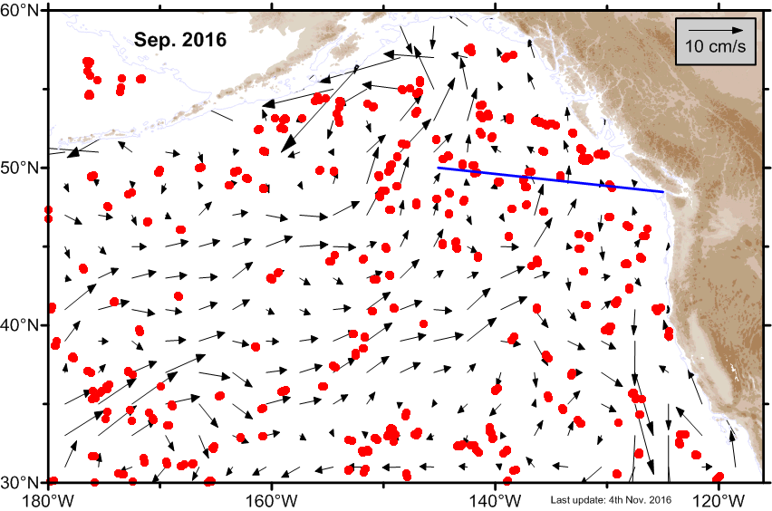 V-Map V-Map
|
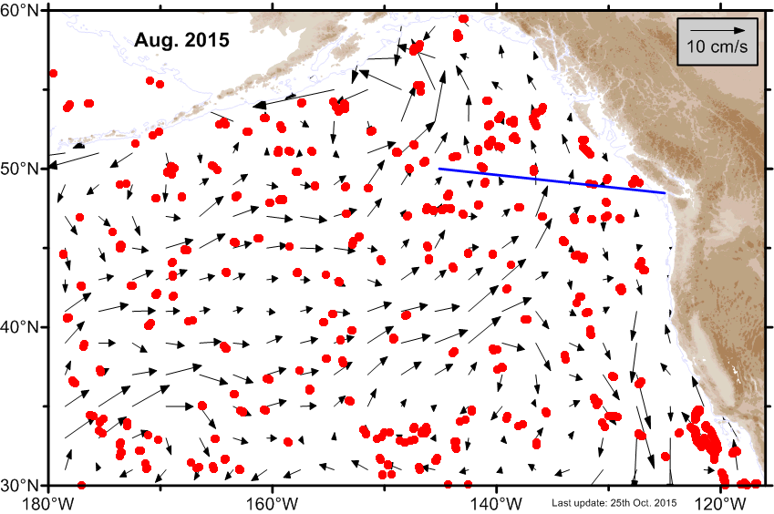
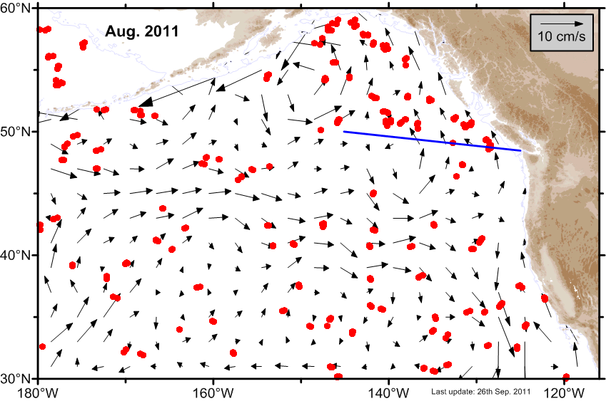
| August |
 Ψ-Map Ψ-Map
|
 ε-Map ε-Map
|
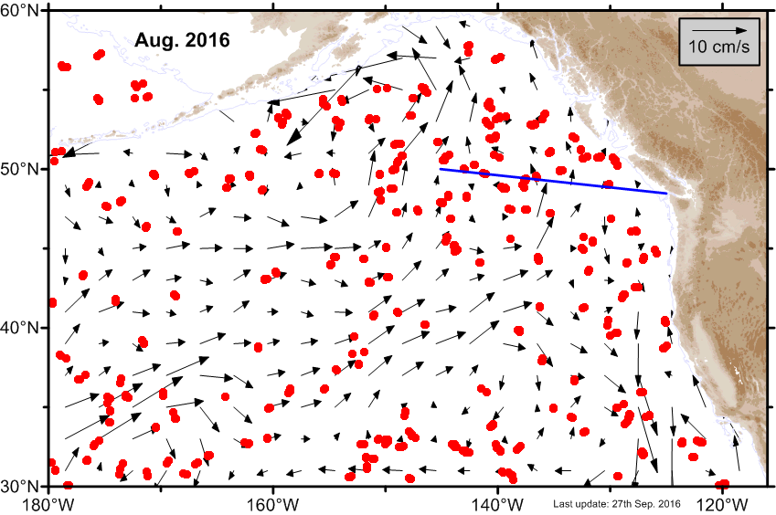 V-Map V-Map
|
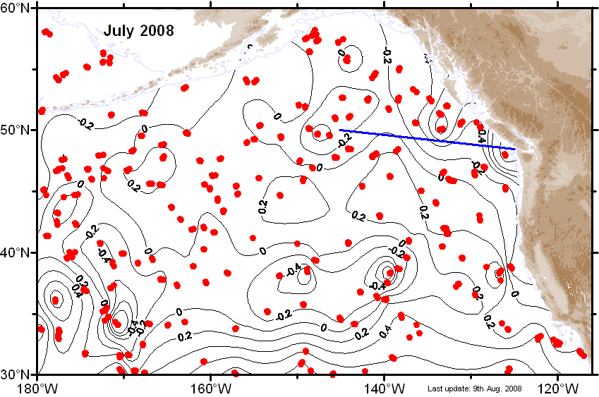
| July |
 Ψ-Map Ψ-Map
|
 ε-Map ε-Map
|
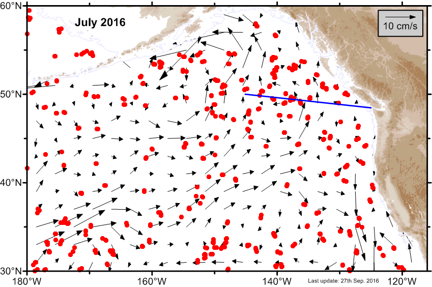 V-Map V-Map
|
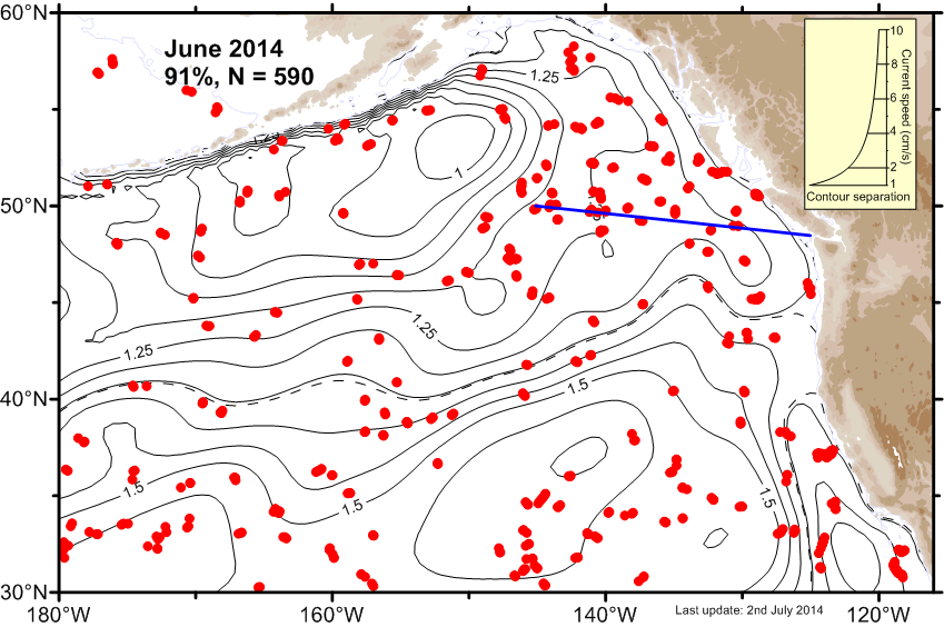
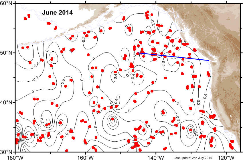
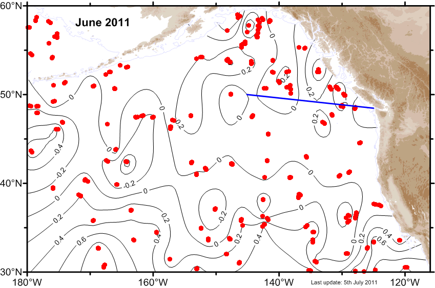
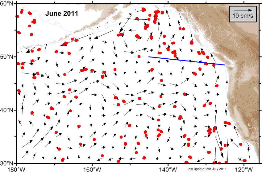
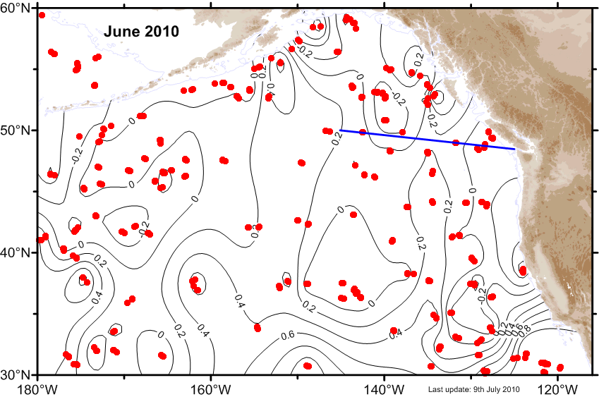
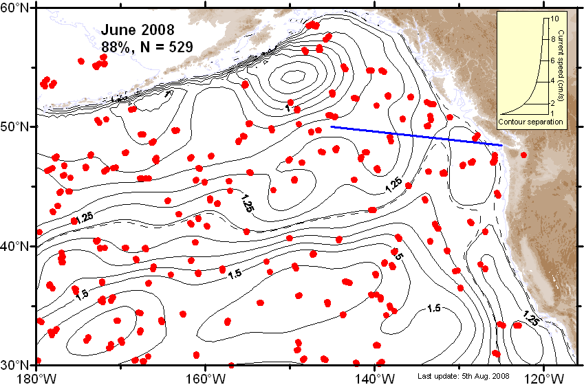
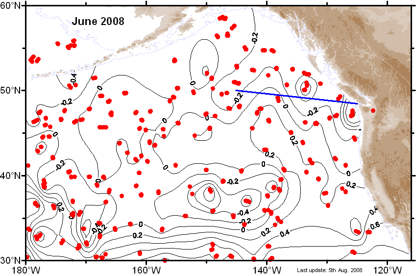
| June |
 Ψ-Map Ψ-Map
|
 ε-Map ε-Map
|
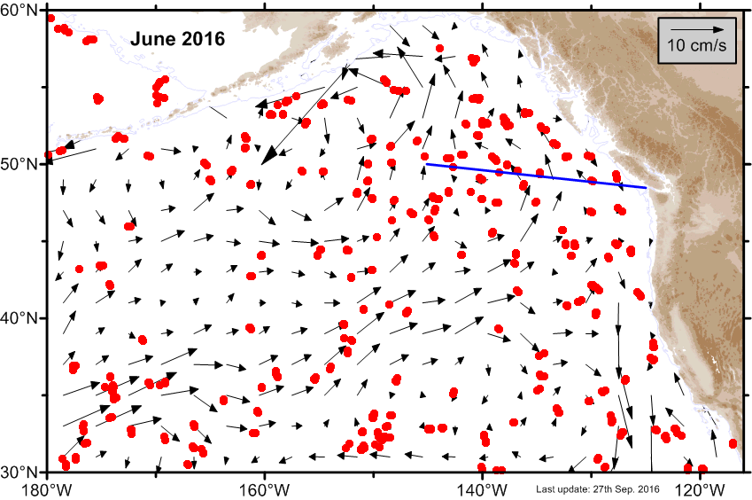 V-Map V-Map
|
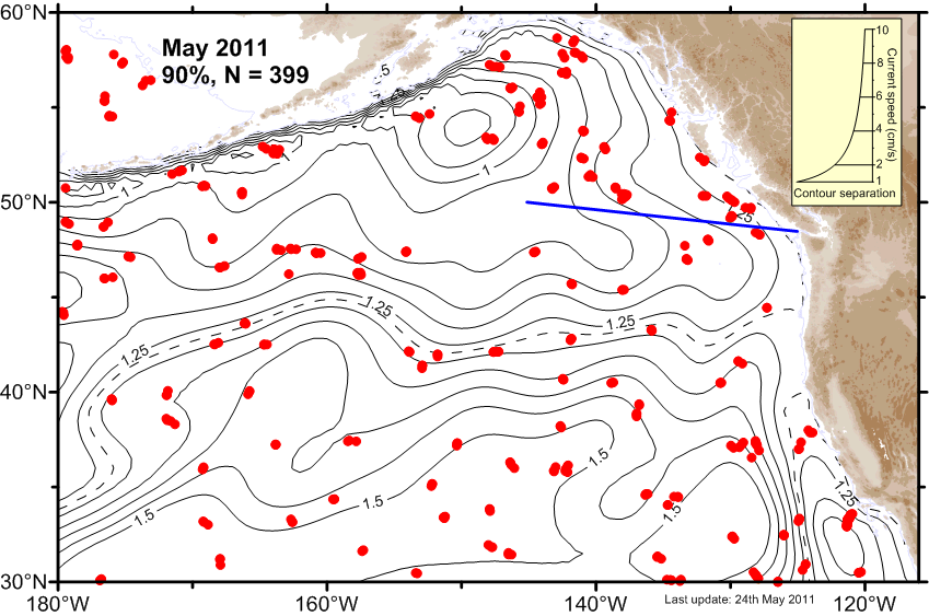
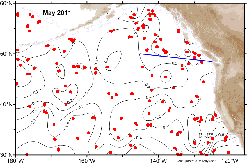
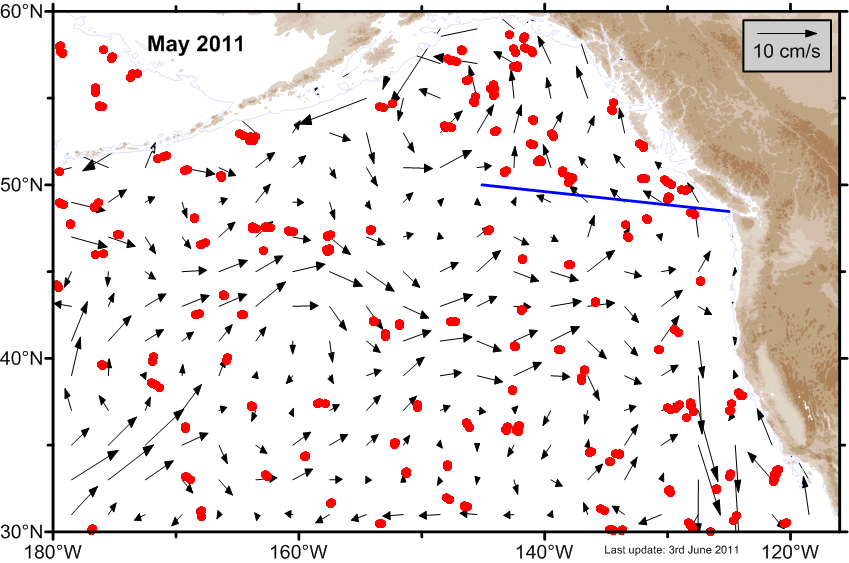
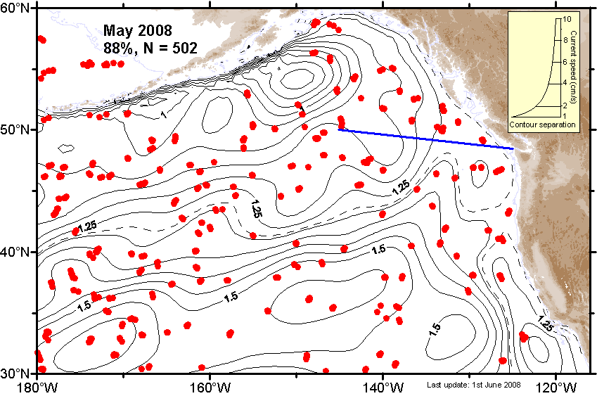
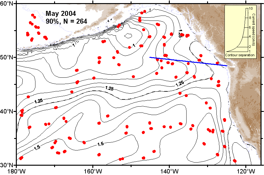
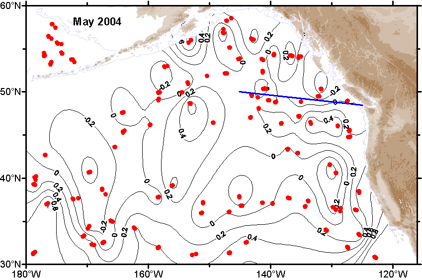
| May |
 Ψ-Map Ψ-Map
|
 ε-Map ε-Map
|
 V-Map V-Map
|
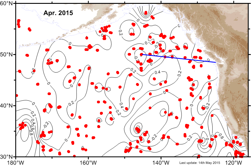
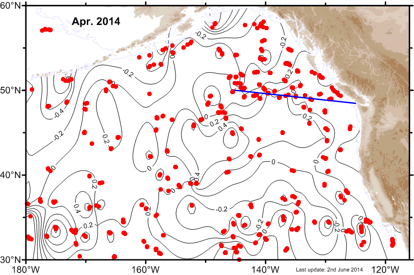
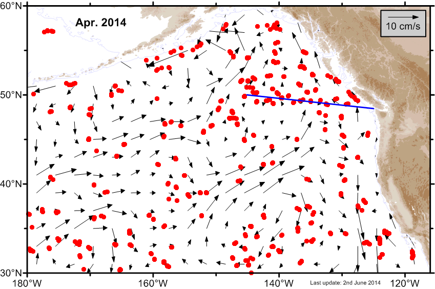
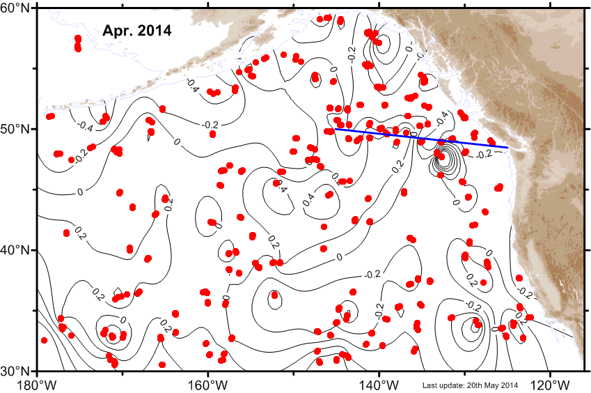
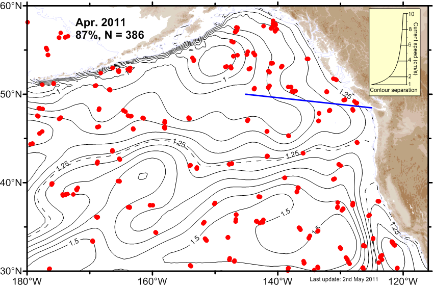
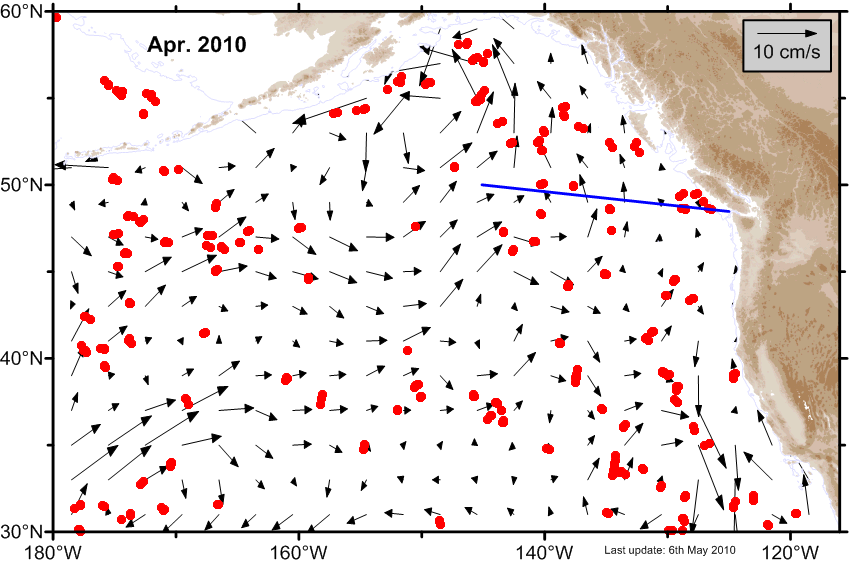
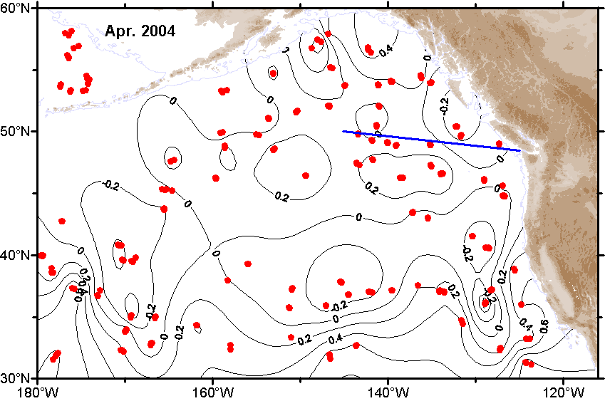
| April |
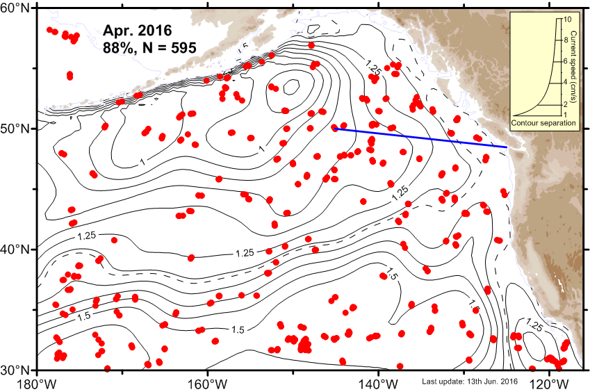 Ψ-Map Ψ-Map
|
 ε-Map ε-Map
|
 V-Map V-Map
|
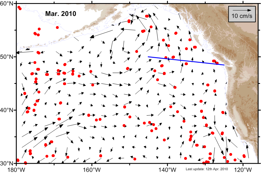
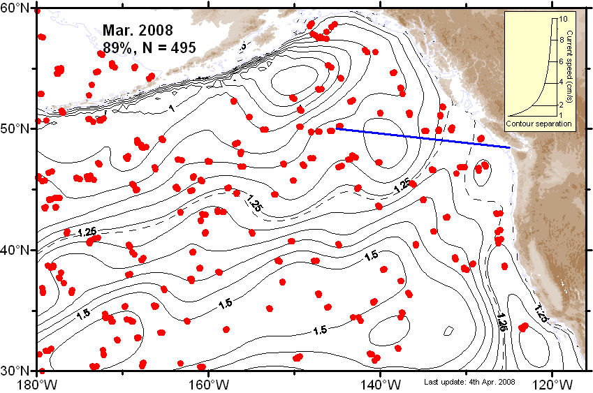
| March |
 Ψ-Map Ψ-Map
|
 ε-Map ε-Map
|
 V-Map V-Map
|
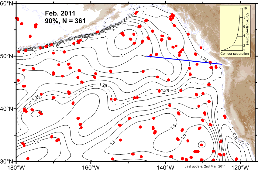
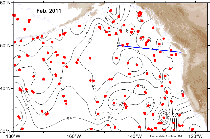
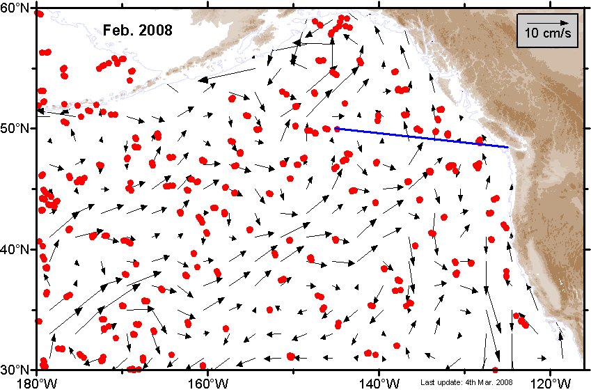
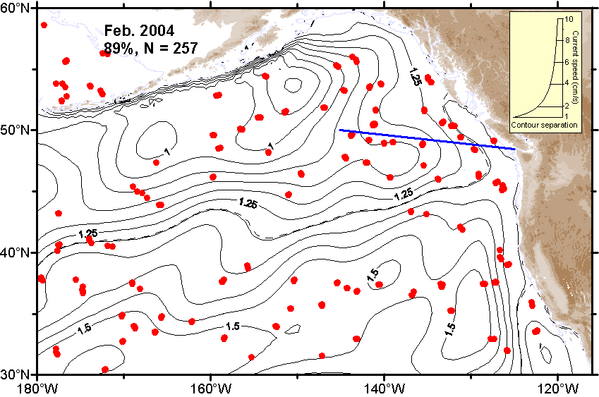
| February |
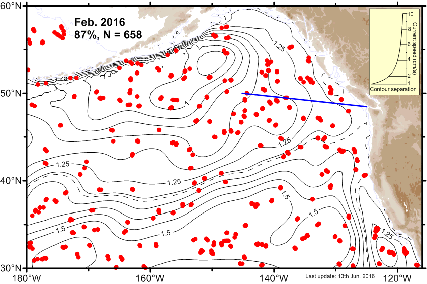 Ψ-Map Ψ-Map
|
 ε-Map ε-Map
|
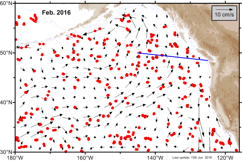 V-Map V-Map
|
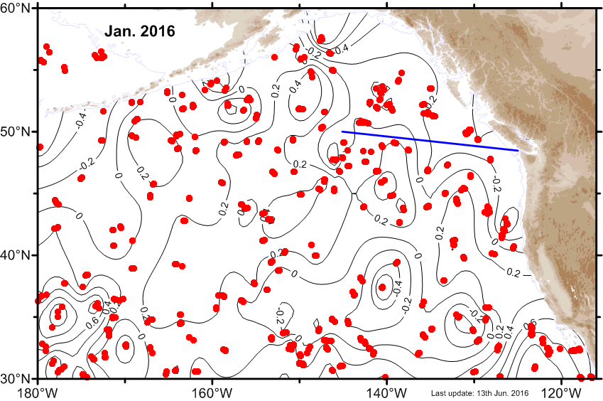
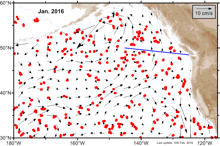
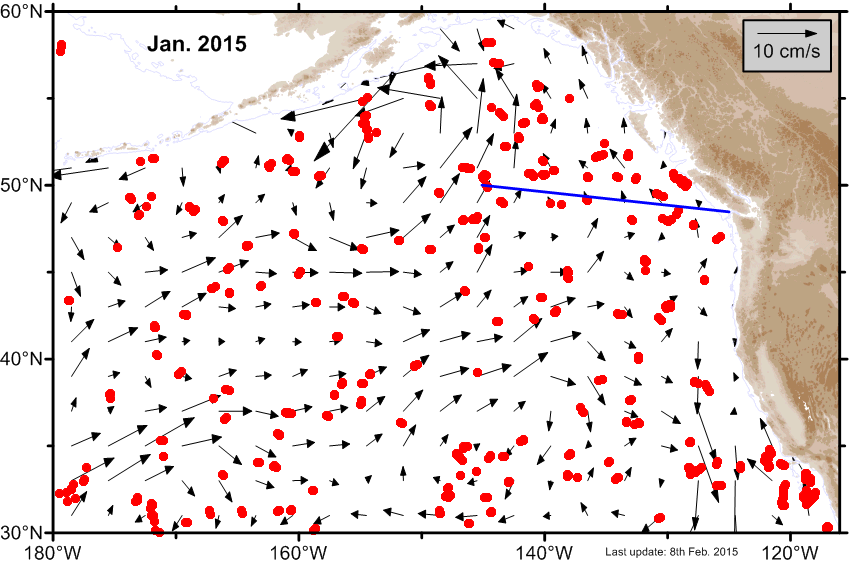
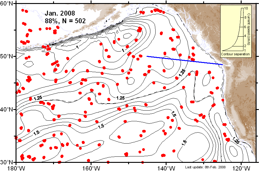
| January |
 Ψ-Map Ψ-Map
|
 ε-Map ε-Map
|
 V-Map V-Map
|
2015 |
|||
| Month | Circulation maps | Error maps | Velocity maps |
|---|---|---|---|
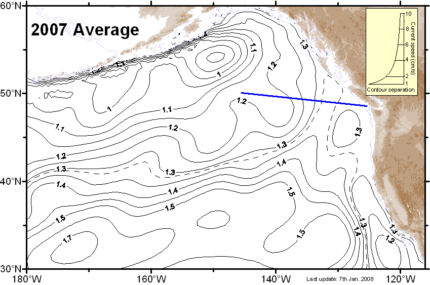
| Average |
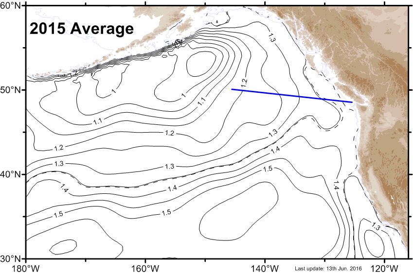 Ψ-Map Ψ-Map
|
ε-Map |
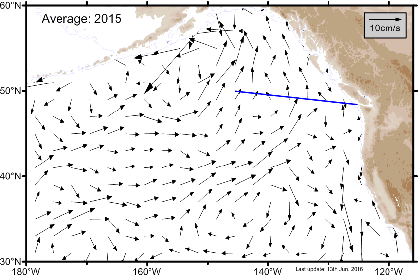 V-Map V-Map
|
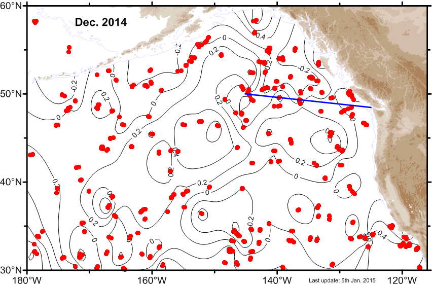
| December |
 Ψ-Map Ψ-Map
|
 ε-Map ε-Map
|
 V-Map V-Map
|
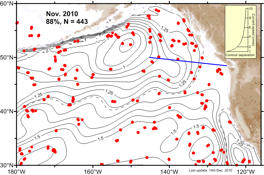
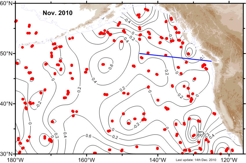
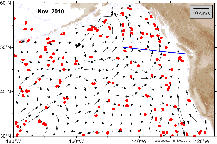
| November |
 Ψ-Map Ψ-Map
|
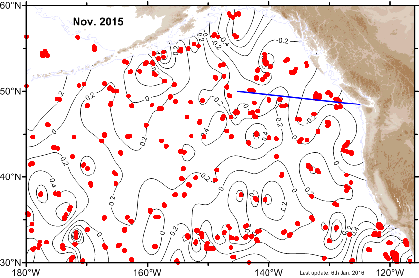 ε-Map ε-Map
|
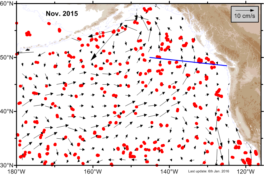 V-Map V-Map
|
| October |
 Ψ-Map Ψ-Map
|
 ε-Map ε-Map
|
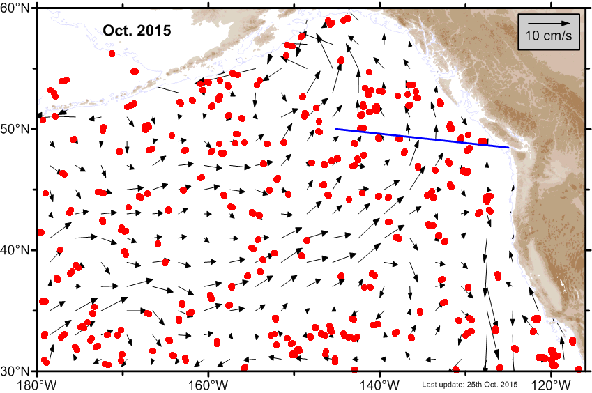 V-Map V-Map
|
| September |
 Ψ-Map Ψ-Map
|
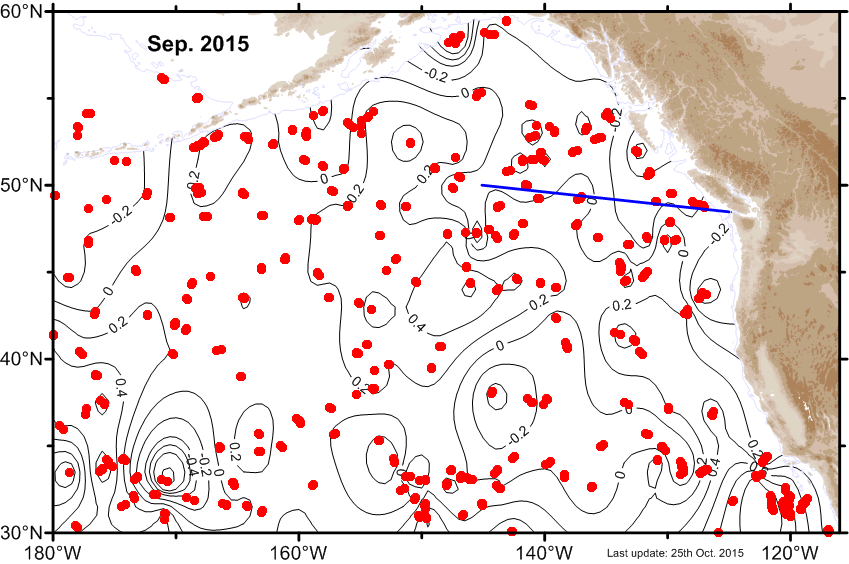 ε-Map ε-Map
|
 V-Map V-Map
|
| August |
 Ψ-Map Ψ-Map
|
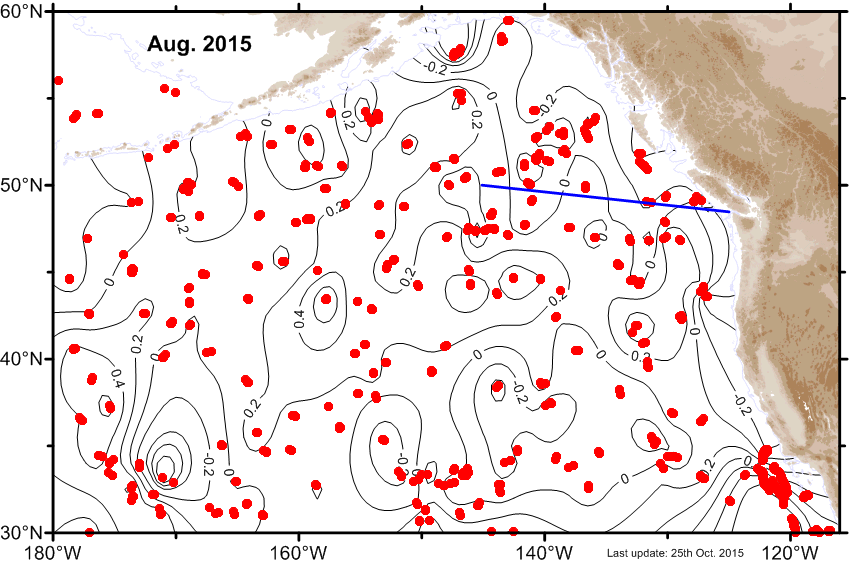 ε-Map ε-Map
|
 V-Map V-Map
|
| July |
 Ψ-Map Ψ-Map
|
 ε-Map ε-Map
|
 V-Map V-Map
|
| June |
 Ψ-Map Ψ-Map
|
 ε-Map ε-Map
|
 V-Map V-Map
|
| May |
 Ψ-Map Ψ-Map
|
 ε-Map ε-Map
|
 V-Map V-Map
|
| April |
 Ψ-Map Ψ-Map
|
 ε-Map ε-Map
|
 V-Map V-Map
|
| March |
 Ψ-Map Ψ-Map
|
 ε-Map ε-Map
|
 V-Map V-Map
|
| February |
 Ψ-Map Ψ-Map
|
 ε-Map ε-Map
|
 V-Map V-Map
|
| January |
 Ψ-Map Ψ-Map
|
 ε-Map ε-Map
|
 V-Map V-Map
|
2014 |
|||
| Month | Circulation maps | Error maps | Velocity maps |
|---|---|---|---|
| Average |
 Ψ-Map Ψ-Map
|
ε-Map |
 V-Map V-Map
|
| December |
 Ψ-Map Ψ-Map
|
 ε-Map ε-Map
|
 V-Map V-Map
|
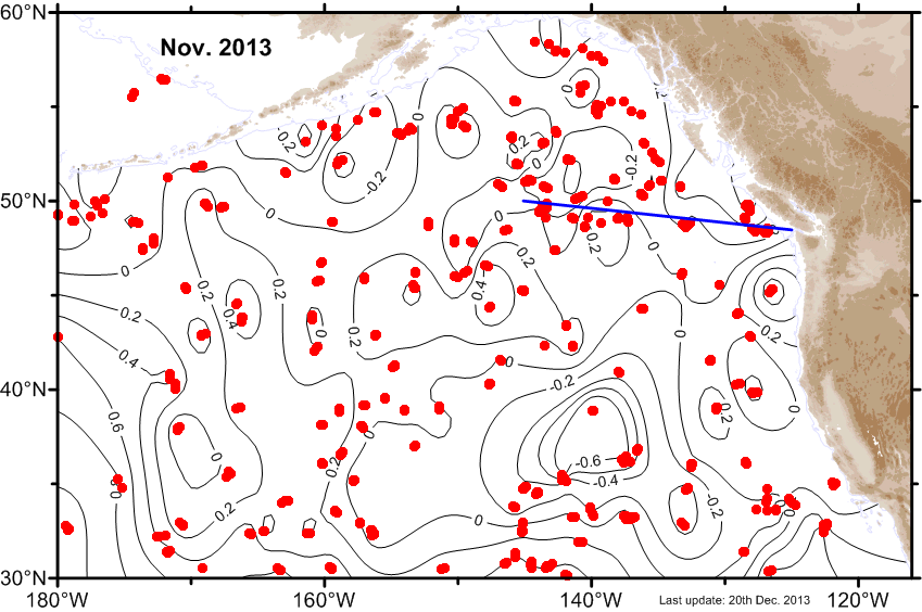
| November |
 Ψ-Map Ψ-Map
|
 ε-Map ε-Map
|
 V-Map V-Map
|
| October |
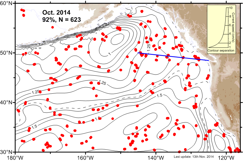 Ψ-Map Ψ-Map
|
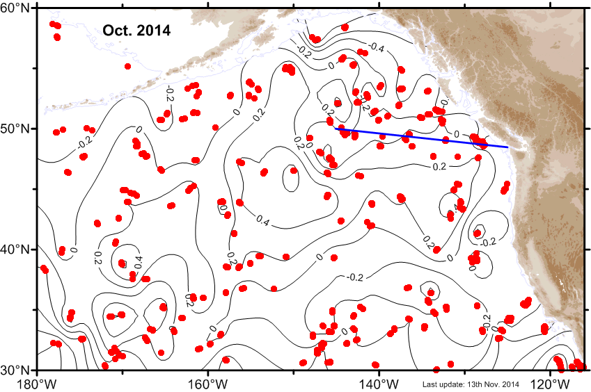 ε-Map ε-Map
|
 V-Map V-Map
|
| September |
 Ψ-Map Ψ-Map
|
 ε-Map ε-Map
|
 V-Map V-Map
|
| August |
 Ψ-Map Ψ-Map
|
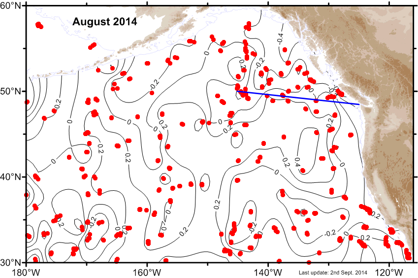 ε-Map ε-Map
|
 V-Map V-Map
|
| July |
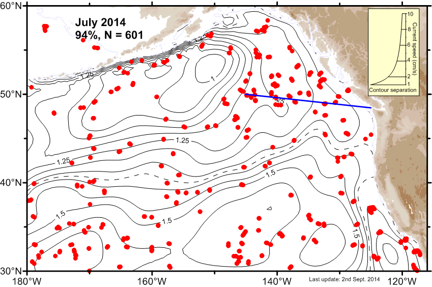 Ψ-Map Ψ-Map
|
 ε-Map ε-Map
|
 V-Map V-Map
|
| June |
 Ψ-Map Ψ-Map
|
 ε-Map ε-Map
|
 V-Map V-Map
|
| May |
 Ψ-Map Ψ-Map
|
 ε-Map ε-Map
|
 V-Map V-Map
|
| April |
 Ψ-Map Ψ-Map
|
 ε-Map ε-Map
|
 V-Map V-Map
|
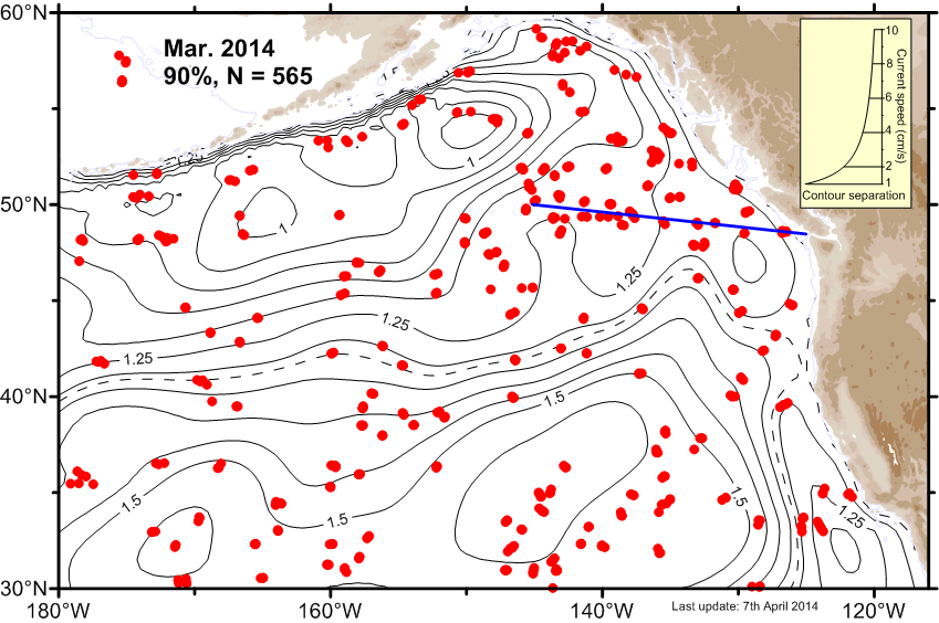
| March |
 Ψ-Map Ψ-Map
|
 ε-Map ε-Map
|
 V-Map V-Map
|
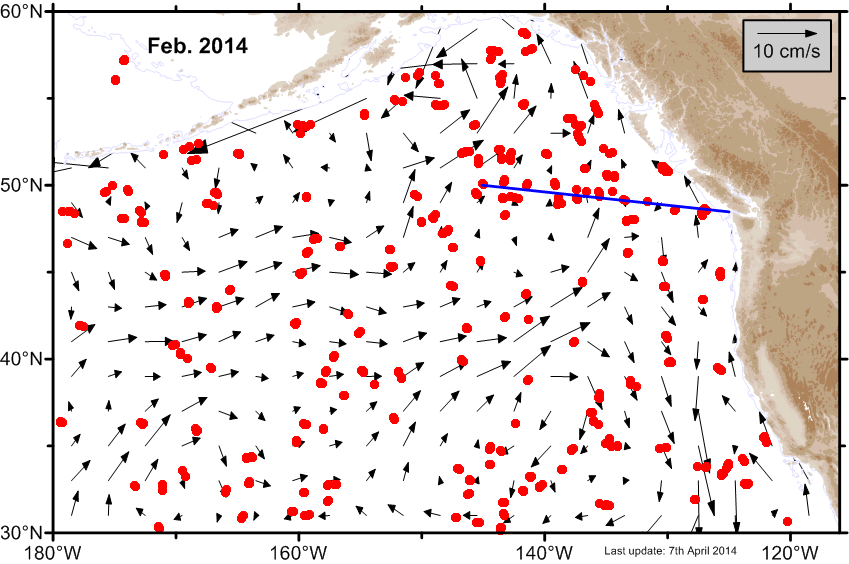
| February |
 Ψ-Map Ψ-Map
|
 ε-Map ε-Map
|
 V-Map V-Map
|
| January |
 Ψ-Map Ψ-Map
|
 ε-Map ε-Map
|
 V-Map V-Map
|
2013 |
|||
| Month | Circulation maps | Error maps | Velocity maps |
|---|---|---|---|
| Average |
 Ψ-Map Ψ-Map
|
ε-Map |
 V-Map V-Map
|
| December |
 Ψ-Map Ψ-Map
|
 ε-Map ε-Map
|
 V-Map V-Map
|
| November |
 Ψ-Map Ψ-Map
|
 ε-Map ε-Map
|
 V-Map V-Map
|
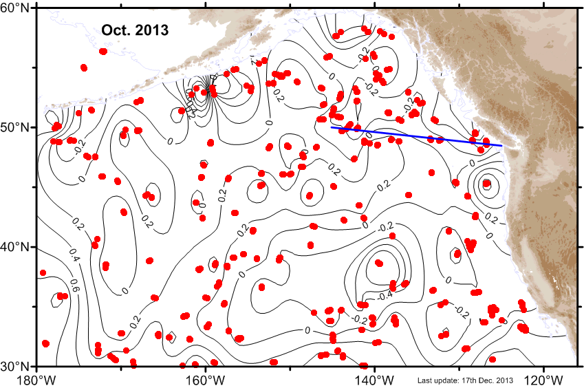
| October |
 Ψ-Map Ψ-Map
|
 ε-Map ε-Map
|
 V-Map V-Map
|
| September |
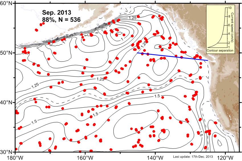 Ψ-Map Ψ-Map
|
 ε-Map ε-Map
|
 V-Map V-Map
|
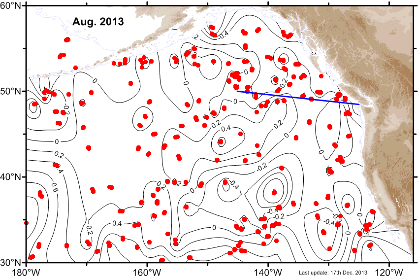
| August |
 Ψ-Map Ψ-Map
|
 ε-Map ε-Map
|
 V-Map V-Map
|
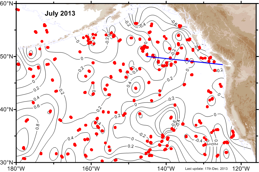
| July |
 Ψ-Map Ψ-Map
|
 ε-Map ε-Map
|
 V-Map V-Map
|
| June |
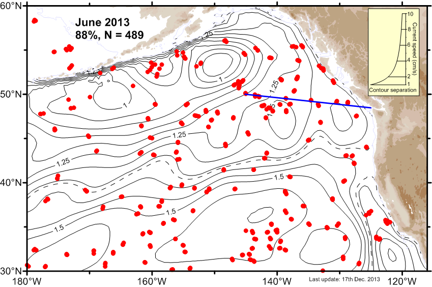 Ψ-Map Ψ-Map
|
 ε-Map ε-Map
|
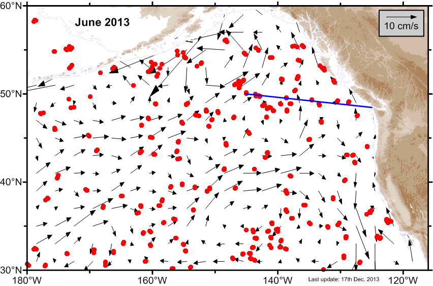 V-Map V-Map
|
| May |
 Ψ-Map Ψ-Map
|
 ε-Map ε-Map
|
 V-Map V-Map
|
| April |
 Ψ-Map Ψ-Map
|
 ε-Map ε-Map
|
 V-Map V-Map
|
| March |
 Ψ-Map Ψ-Map
|
 ε-Map ε-Map
|
 V-Map V-Map
|
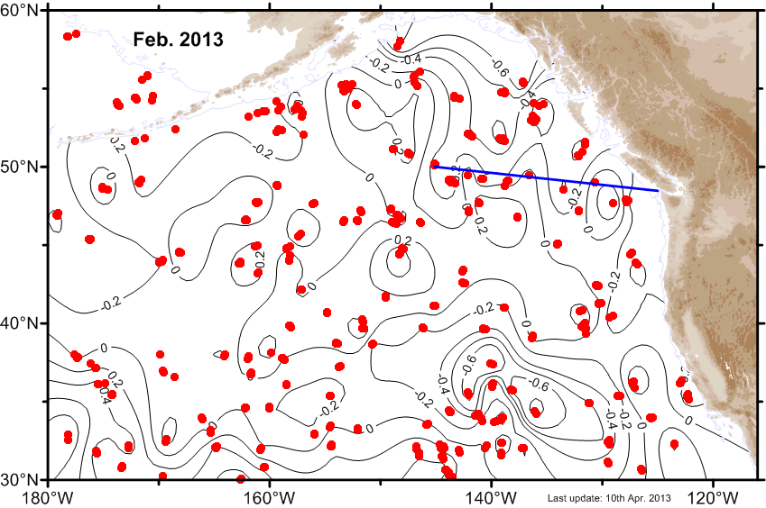
| February |
 Ψ-Map Ψ-Map
|
 ε-Map ε-Map
|
 V-Map V-Map
|
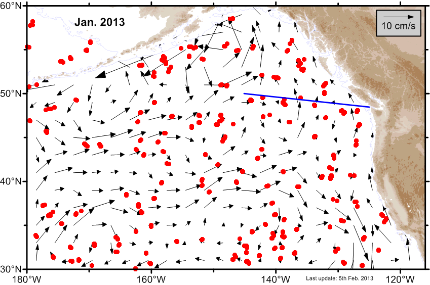
| January |
 Ψ-Map Ψ-Map
|
 ε-Map ε-Map
|
 V-Map V-Map
|
2012 |
|||
| Month | Circulation maps | Error maps | Velocity maps |
|---|---|---|---|
| Average |
 Ψ-Map Ψ-Map
|
ε-Map |
 V-Map V-Map
|
| December |
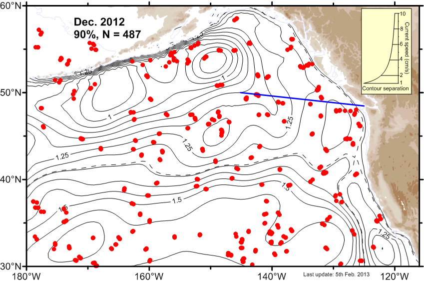 Ψ-Map Ψ-Map
|
 ε-Map ε-Map
|
 V-Map V-Map
|
| November |
 Ψ-Map Ψ-Map
|
 ε-Map ε-Map
|
 V-Map V-Map
|
| October |
 Ψ-Map Ψ-Map
|
 ε-Map ε-Map
|
 V-Map V-Map
|
| September |
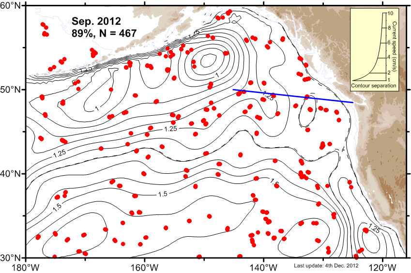 Ψ-Map Ψ-Map
|
 ε-Map ε-Map
|
 V-Map V-Map
|
| August |
 Ψ-Map Ψ-Map
|
 ε-Map ε-Map
|
 V-Map V-Map
|
| July |
 Ψ-Map Ψ-Map
|
 ε-Map ε-Map
|
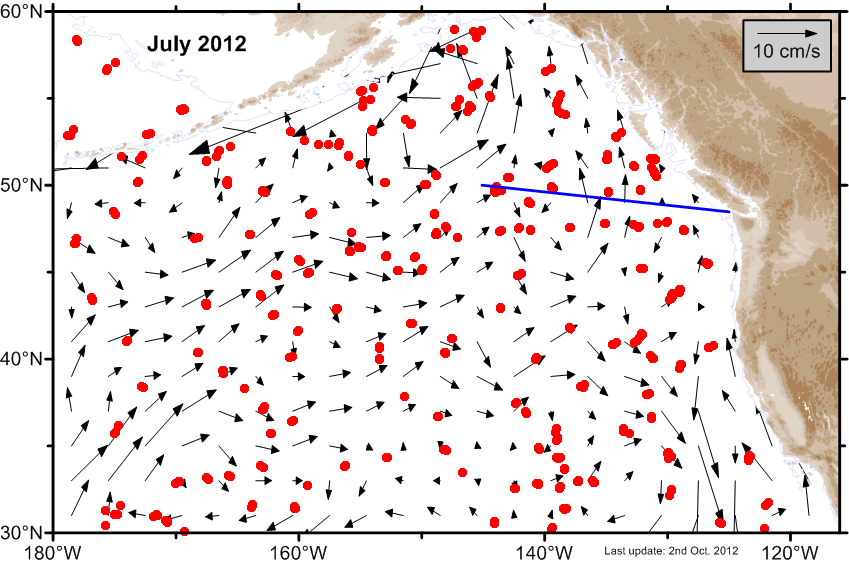 V-Map V-Map
|
| June |
 Ψ-Map Ψ-Map
|
 ε-Map ε-Map
|
 V-Map V-Map
|
| May |
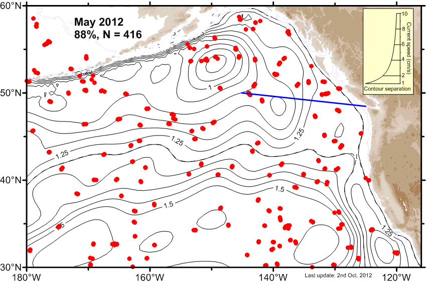 Ψ-Map Ψ-Map
|
 ε-Map ε-Map
|
 V-Map V-Map
|
| April |
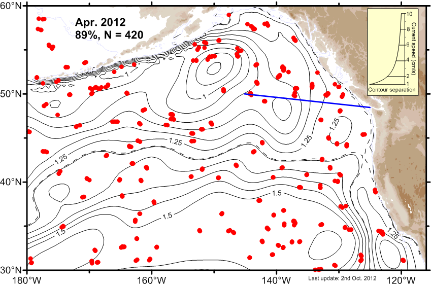 Ψ-Map Ψ-Map
|
 ε-Map ε-Map
|
 V-Map V-Map
|
| March |
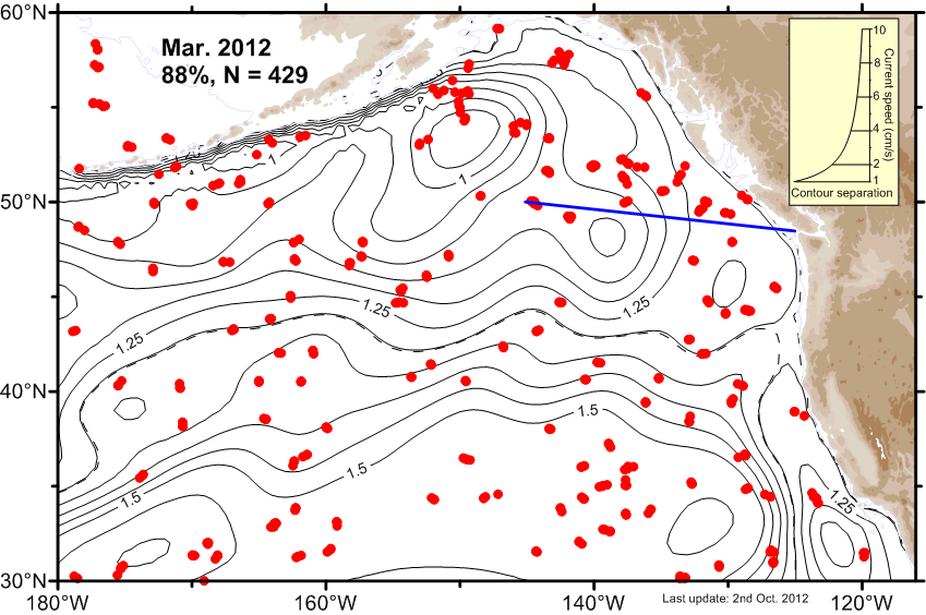 Ψ-Map Ψ-Map
|
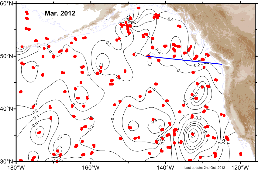 ε-Map ε-Map
|
 V-Map V-Map
|
| February |
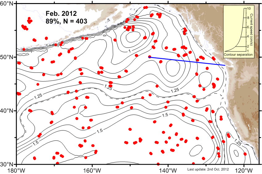 Ψ-Map Ψ-Map
|
 ε-Map ε-Map
|
 V-Map V-Map
|
| January |
 Ψ-Map Ψ-Map
|
 ε-Map ε-Map
|
 V-Map V-Map
|
2011 |
|||
| Month | Circulation maps | Error maps | Velocity maps |
|---|---|---|---|
| Average |
 Ψ-Map Ψ-Map
|
ε-Map |
 V-Map V-Map
|
| December |
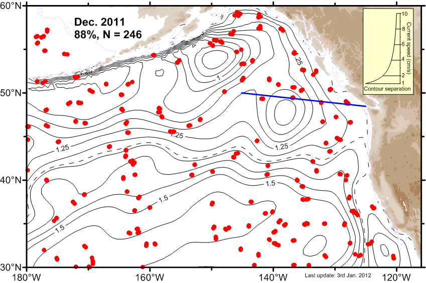 Ψ-Map Ψ-Map
|
 ε-Map ε-Map
|
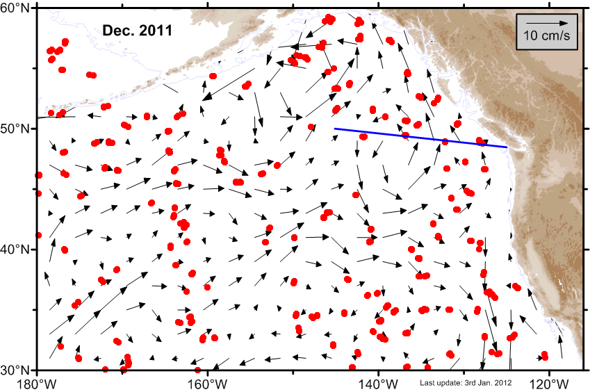 V-Map V-Map
|
| November |
 Ψ-Map Ψ-Map
|
 ε-Map ε-Map
|
 V-Map V-Map
|
| October |
 Ψ-Map Ψ-Map
|
 ε-Map ε-Map
|
 V-Map V-Map
|
| September |
 Ψ-Map Ψ-Map
|
 ε-Map ε-Map
|
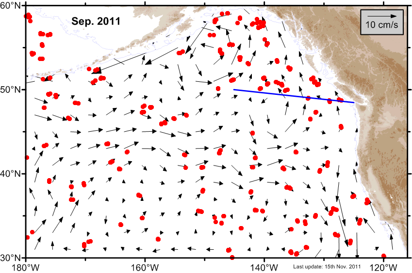 V-Map V-Map
|
| August |
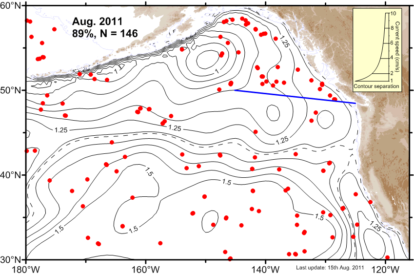 Ψ-Map Ψ-Map
|
 ε-Map ε-Map
|
 V-Map V-Map
|
| July |
 Ψ-Map Ψ-Map
|
 ε-Map ε-Map
|
 V-Map V-Map
|
| June |
 Ψ-Map Ψ-Map
|
 ε-Map ε-Map
|
 V-Map V-Map
|
| May |
 Ψ-Map Ψ-Map
|
 ε-Map ε-Map
|
 V-Map V-Map
|
| April |
 Ψ-Map Ψ-Map
|
 ε-Map ε-Map
|
 V-Map V-Map
|
| March |
 Ψ-Map Ψ-Map
|
 ε-Map ε-Map
|
 V-Map V-Map
|
| February |
 Ψ-Map Ψ-Map
|
 ε-Map ε-Map
|
 V-Map V-Map
|
| January |
 Ψ-Map Ψ-Map
|
 ε-Map ε-Map
|
 V-Map V-Map
|
2010 |
|||
| Month | Circulation maps | Error maps | Velocity maps |
|---|---|---|---|
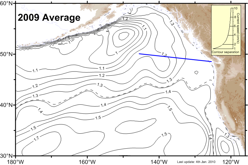
| Average |
 Ψ-Map Ψ-Map
|
ε-Map |
 V-Map V-Map
|
| December |
 Ψ-Map Ψ-Map
|
 ε-Map ε-Map
|
 V-Map V-Map
|
| November |
 Ψ-Map Ψ-Map
|
 ε-Map ε-Map
|
 V-Map V-Map
|
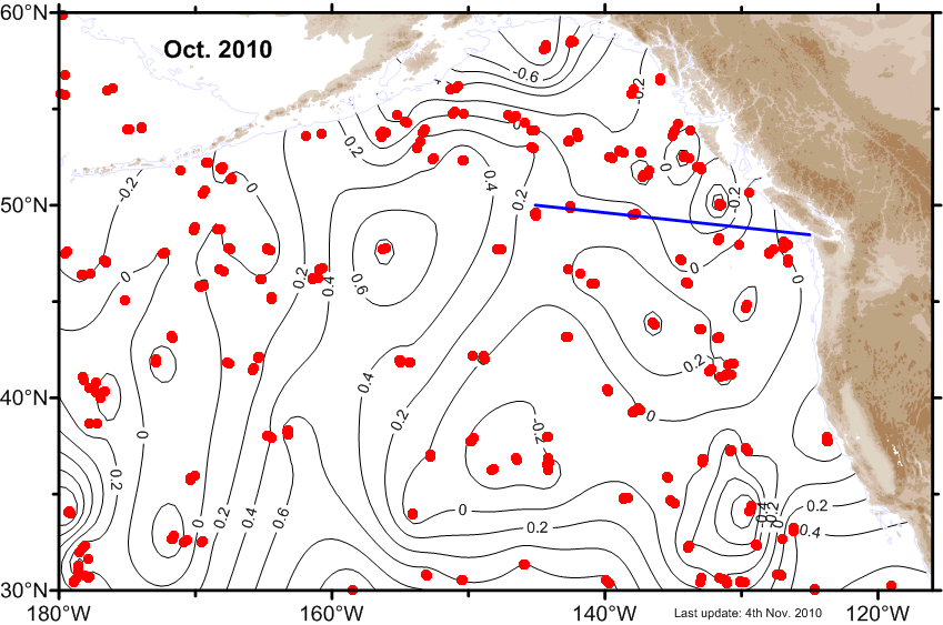
| October |
 Ψ-Map Ψ-Map
|
 ε-Map ε-Map
|
 V-Map V-Map
|
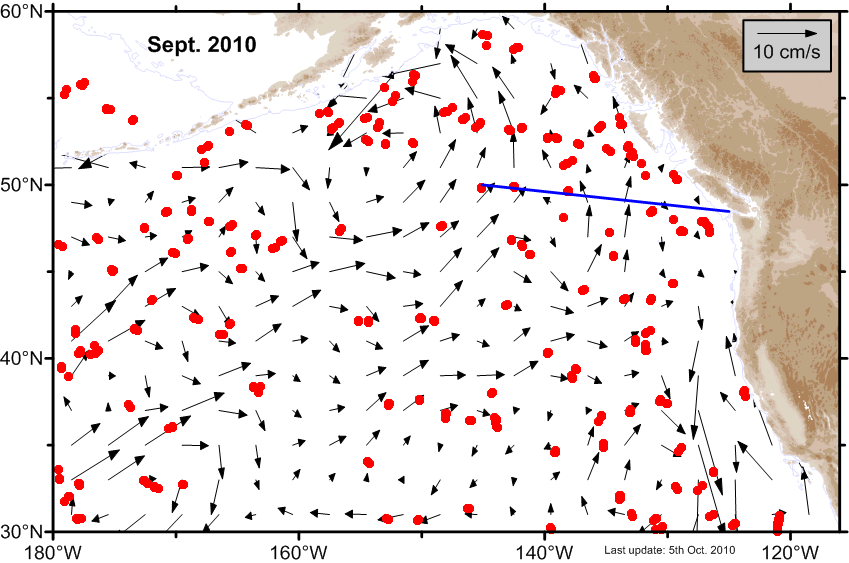
| September |
 Ψ-Map Ψ-Map
|
 ε-Map ε-Map
|
 V-Map V-Map
|
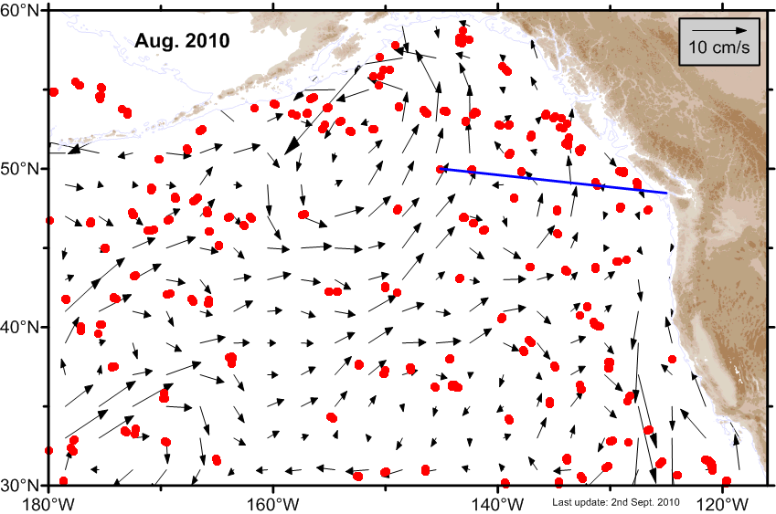
| August |
 Ψ-Map Ψ-Map
|
 ε-Map ε-Map
|
 V-Map V-Map
|
| July |
 Ψ-Map Ψ-Map
|
 ε-Map ε-Map
|
 V-Map V-Map
|
| June |
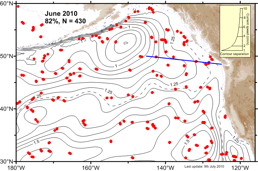 Ψ-Map Ψ-Map
|
 ε-Map ε-Map
|
 V-Map V-Map
|
| May |
 Ψ-Map Ψ-Map
|
 ε-Map ε-Map
|
 V-Map V-Map
|
| April |
 Ψ-Map Ψ-Map
|
 ε-Map ε-Map
|
 V-Map V-Map
|
| March |
 Ψ-Map Ψ-Map
|
 ε-Map ε-Map
|
 V-Map V-Map
|
| February |
 Ψ-Map Ψ-Map
|
 ε-Map ε-Map
|
 V-Map V-Map
|
| January |
 Ψ-Map Ψ-Map
|
 ε-Map ε-Map
|
 V-Map V-Map
|
2009 |
|||
| Month | Circulation maps | Error maps | Velocity maps |
|---|---|---|---|
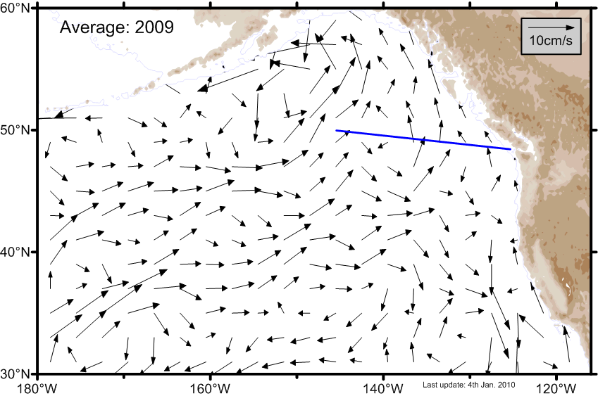
| Average |
 Ψ-Map Ψ-Map
|
ε-Map |
 V-Map V-Map
|
| December |
 Ψ-Map Ψ-Map
|
 ε-Map ε-Map
|
 V-Map V-Map
|
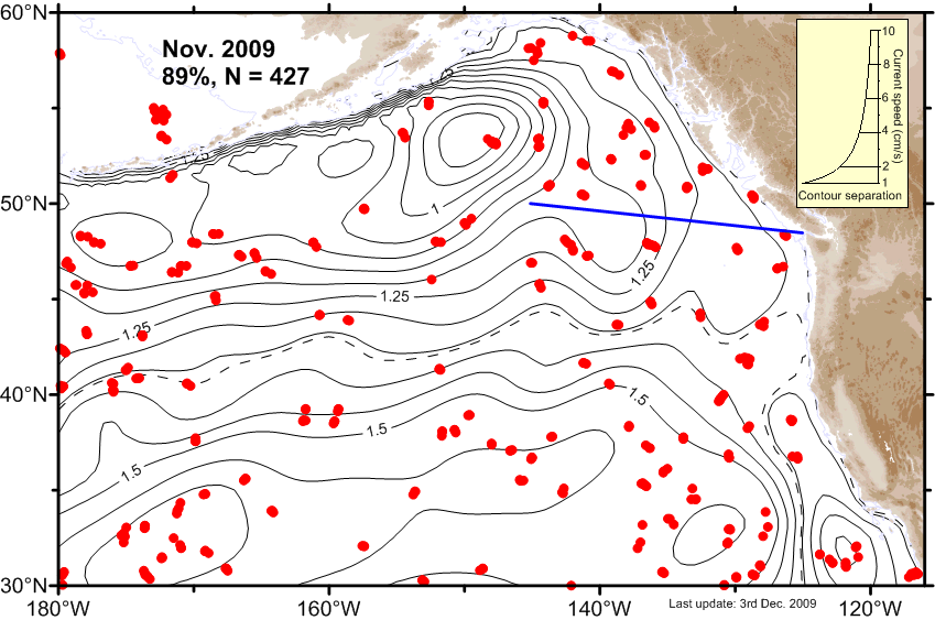
| November |
 Ψ-Map Ψ-Map
|
 ε-Map ε-Map
|
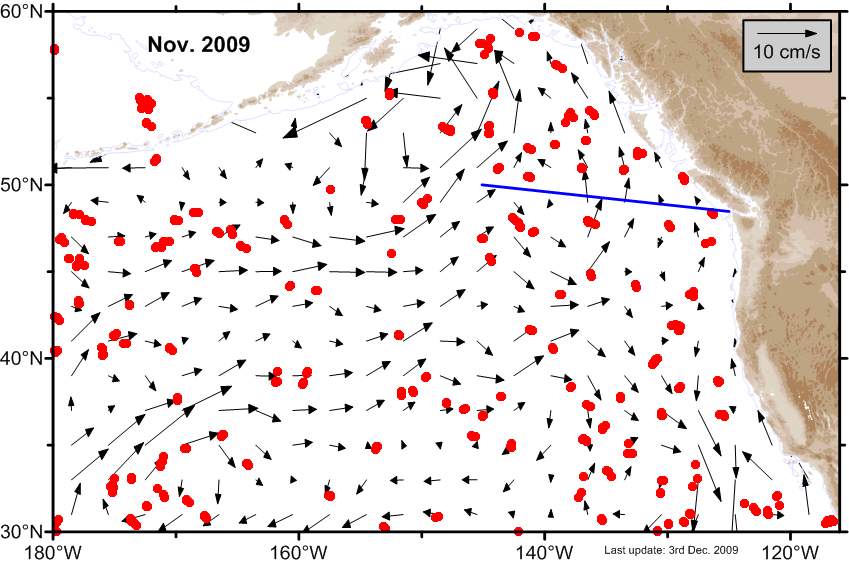 V-Map V-Map
|
| October |
 Ψ-Map Ψ-Map
|
 ε-Map ε-Map
|
 V-Map V-Map
|
| September |
 Ψ-Map Ψ-Map
|
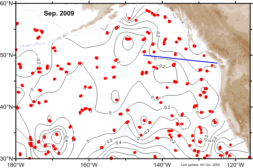 ε-Map ε-Map
|
 V-Map V-Map
|
| August |
 Ψ-Map Ψ-Map
|
 ε-Map ε-Map
|
 V-Map V-Map
|
| July |
 Ψ-Map Ψ-Map
|
 ε-Map ε-Map
|
 V-Map V-Map
|
| June |
 Ψ-Map Ψ-Map
|
 ε-Map ε-Map
|
 V-Map V-Map
|
| May |
 Ψ-Map Ψ-Map
|
 ε-Map ε-Map
|
 V-Map V-Map
|
| April |
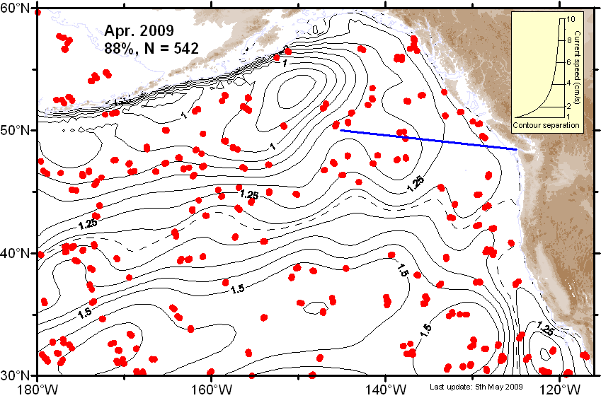 Ψ-Map Ψ-Map
|
 ε-Map ε-Map
|
 V-Map V-Map
|
| March |
 Ψ-Map Ψ-Map
|
 ε-Map ε-Map
|
 V-Map V-Map
|
| February |
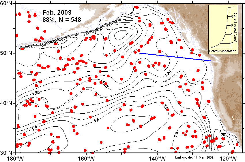 Ψ-Map Ψ-Map
|
 ε-Map ε-Map
|
 V-Map V-Map
|
| January |
 Ψ-Map Ψ-Map
|
 ε-Map ε-Map
|
 V-Map V-Map
|
2008 |
|||
| Month | Circulation maps | Error maps | Velocity maps |
|---|---|---|---|
| Average |
 Ψ-Map Ψ-Map
|
ε-Map |
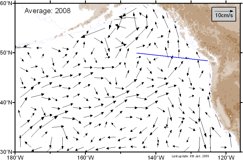 V-Map V-Map
|
| December |
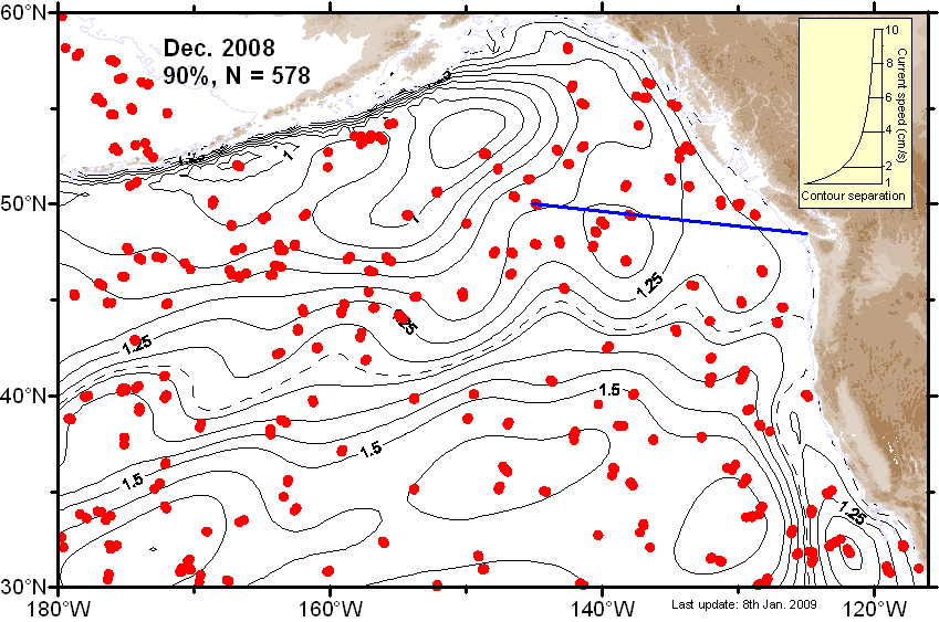 Ψ-Map Ψ-Map
|
 ε-Map ε-Map
|
 V-Map V-Map
|
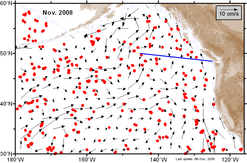
| November |
 Ψ-Map Ψ-Map
|
 ε-Map ε-Map
|
 V-Map V-Map
|
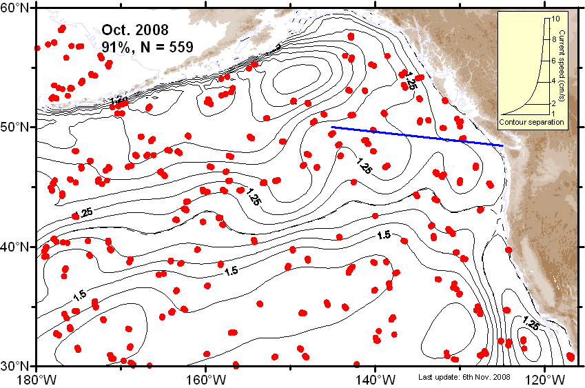
| October |
 Ψ-Map Ψ-Map
|
 ε-Map ε-Map
|
 V-Map V-Map
|
| September |
 Ψ-Map Ψ-Map
|
 ε-Map ε-Map
|
 V-Map V-Map
|
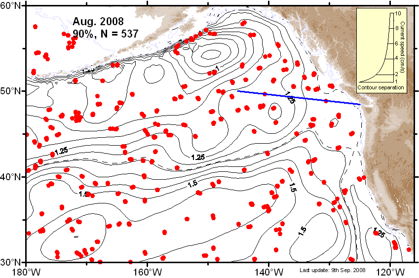
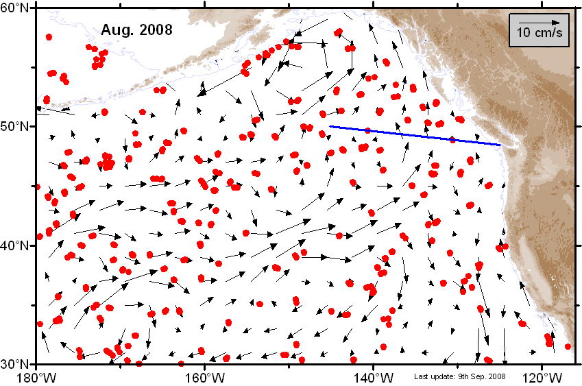
| August |
 Ψ-Map Ψ-Map
|
 ε-Map ε-Map
|
 V-Map V-Map
|
| July |
 Ψ-Map Ψ-Map
|
 ε-Map ε-Map
|
 V-Map V-Map
|
| June |
 Ψ-Map Ψ-Map
|
 ε-Map ε-Map
|
 V-Map V-Map
|
| May |
 Ψ-Map Ψ-Map
|
 ε-Map ε-Map
|
 V-Map V-Map
|
| April |
 Ψ-Map Ψ-Map
|
 ε-Map ε-Map
|
 V-Map V-Map
|
| March |
 Ψ-Map Ψ-Map
|
 ε-Map ε-Map
|
 V-Map V-Map
|
| February |
 Ψ-Map Ψ-Map
|
 ε-Map ε-Map
|
 V-Map V-Map
|
| January |
 Ψ-Map Ψ-Map
|
 ε-Map ε-Map
|
 V-Map V-Map
|
2007 |
|||
| Month | Circulation maps | Error maps | Velocity maps |
|---|---|---|---|
| Average |
 Ψ-Map Ψ-Map
|
ε-Map |
 V-Map V-Map
|
| December |
 Ψ-Map Ψ-Map
|
 ε-Map ε-Map
|
 V-Map V-Map
|
| November |
 Ψ-Map Ψ-Map
|
 ε-Map ε-Map
|
 V-Map V-Map
|
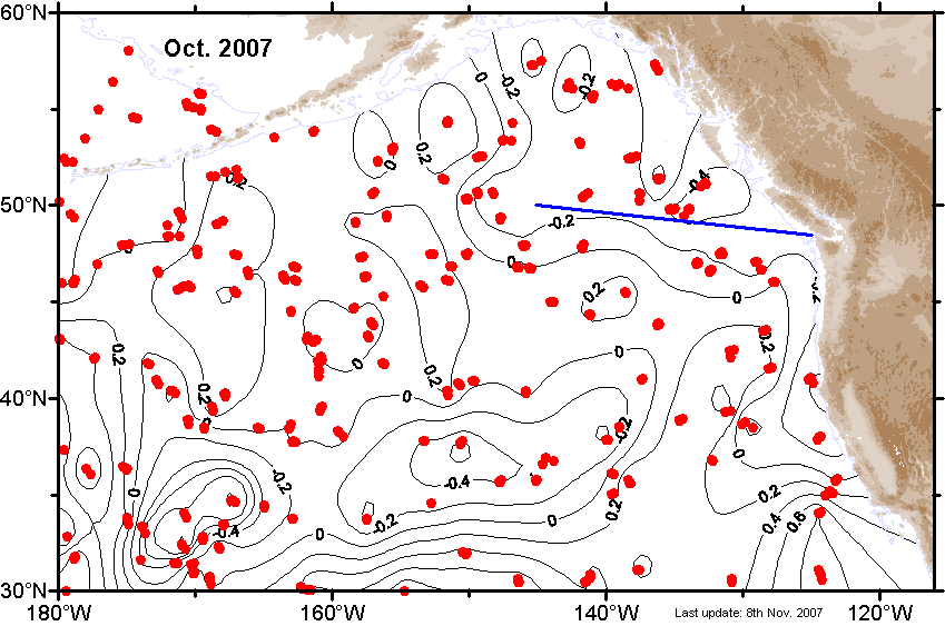
| October |
 Ψ-Map Ψ-Map
|
 ε-Map ε-Map
|
 V-Map V-Map
|
| September |
 Ψ-Map Ψ-Map
|
 ε-Map ε-Map
|
 V-Map V-Map
|
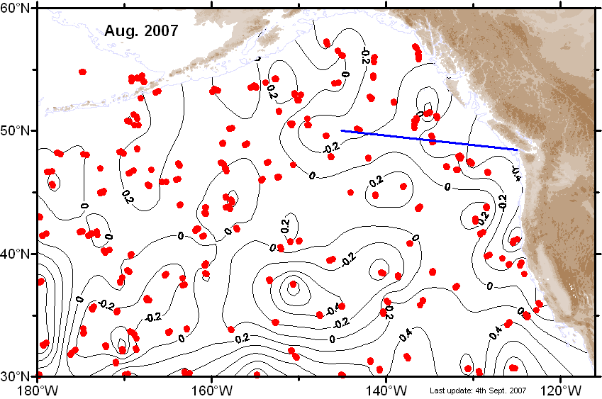
| August |
 Ψ-Map Ψ-Map
|
 ε-Map ε-Map
|
 V-Map V-Map
|
| July |
 Ψ-Map Ψ-Map
|
 ε-Map ε-Map
|
 V-Map V-Map
|
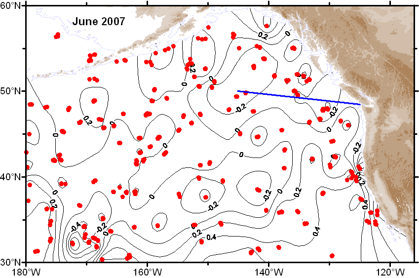
| June |
 Ψ-Map Ψ-Map
|
 ε-Map ε-Map
|
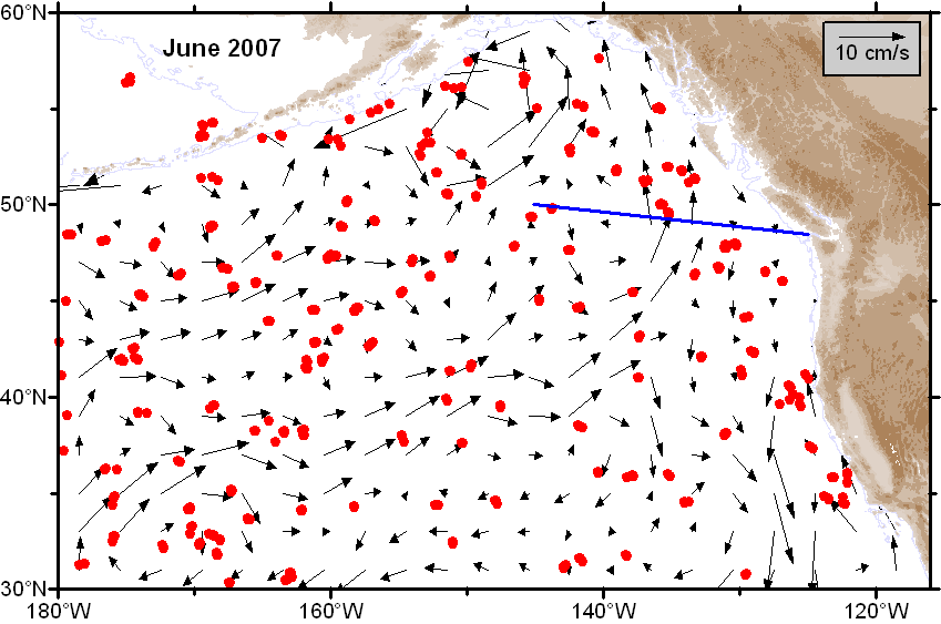 V-Map V-Map
|
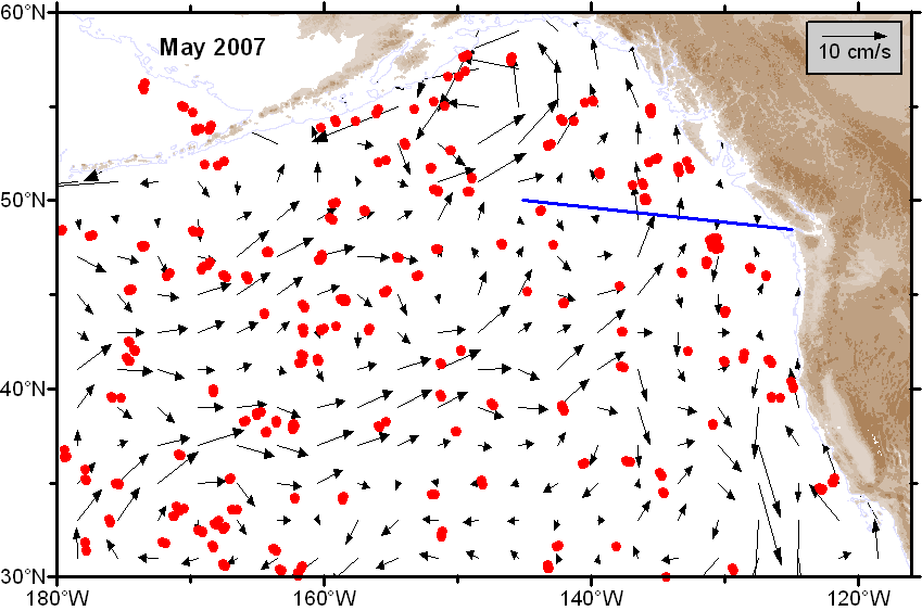
| May |
 Ψ-Map Ψ-Map
|
 ε-Map ε-Map
|
 V-Map V-Map
|
| April |
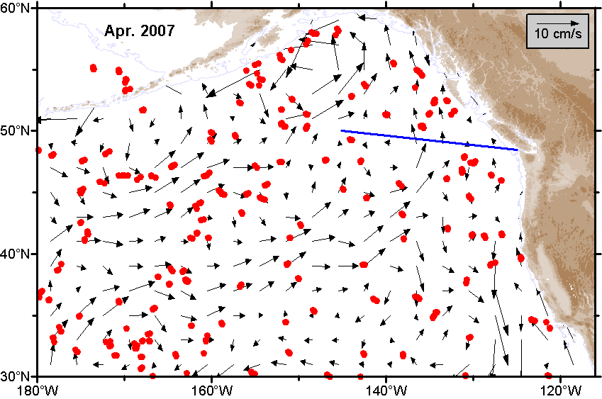
 Ψ-Map Ψ-Map
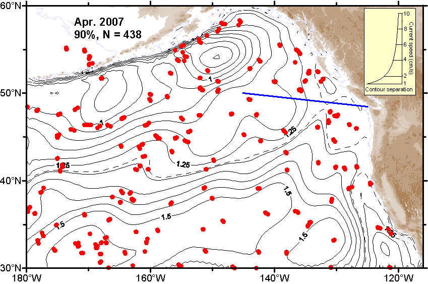
|
 ε-Map ε-Map
|
 V-Map V-Map
|
| March |
 Ψ-Map Ψ-Map
|
 ε-Map ε-Map
|
 V-Map V-Map
|
| February |
 Ψ-Map Ψ-Map
|
 ε-Map ε-Map
|
 V-Map V-Map
|
| January |
 Ψ-Map Ψ-Map
|
 ε-Map ε-Map
|
 V-Map V-Map
|
2006 |
|||
| Month | Circulation maps | Error maps | Velocity maps |
|---|---|---|---|
| Average |
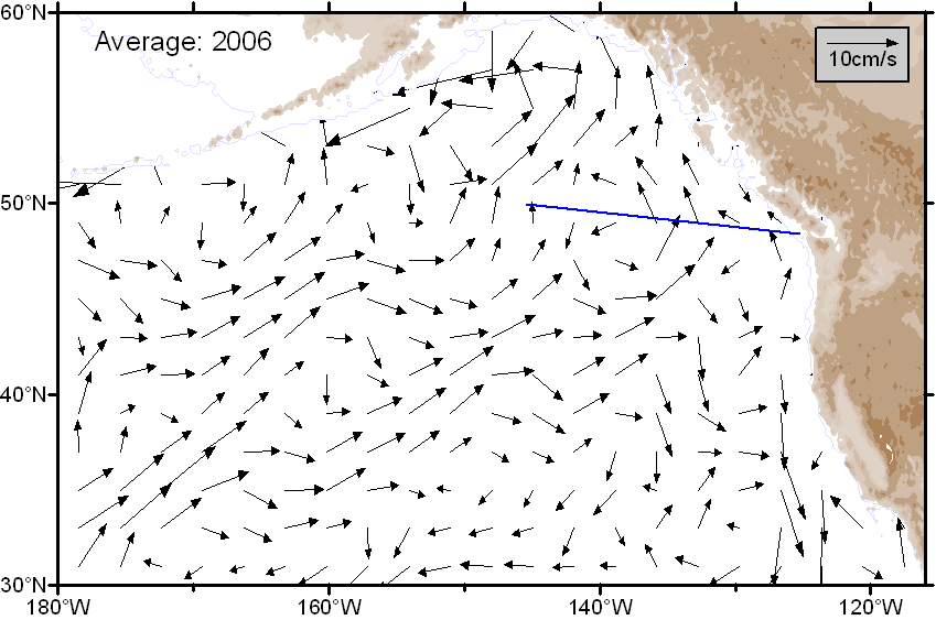
 Ψ-Map Ψ-Map
|
ε-Map |
 V-Map V-Map
|
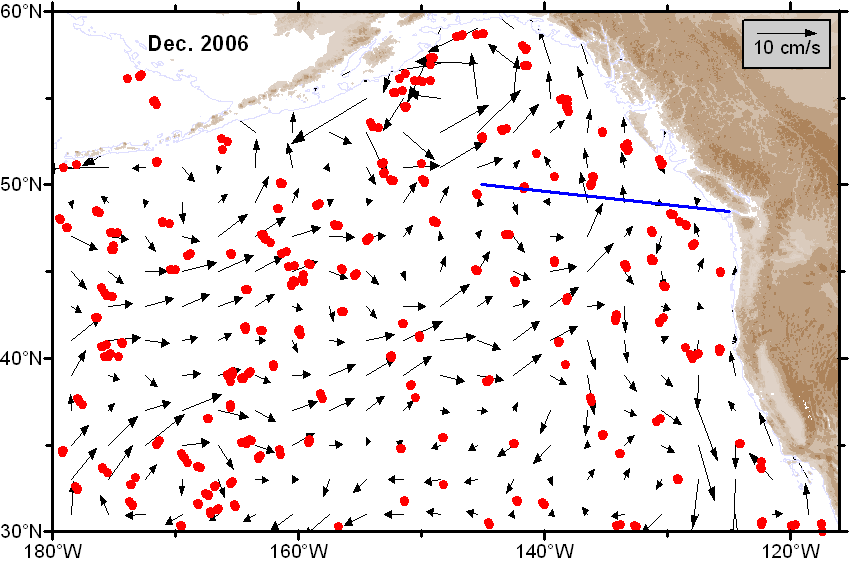
| December |
 Ψ-Map Ψ-Map
|
 ε-Map ε-Map
|
 V-Map V-Map
|
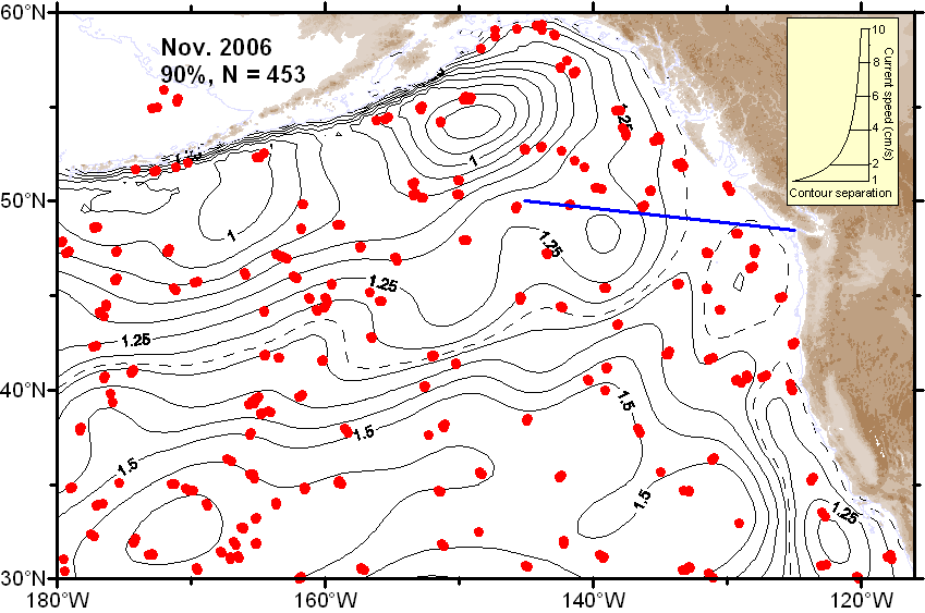
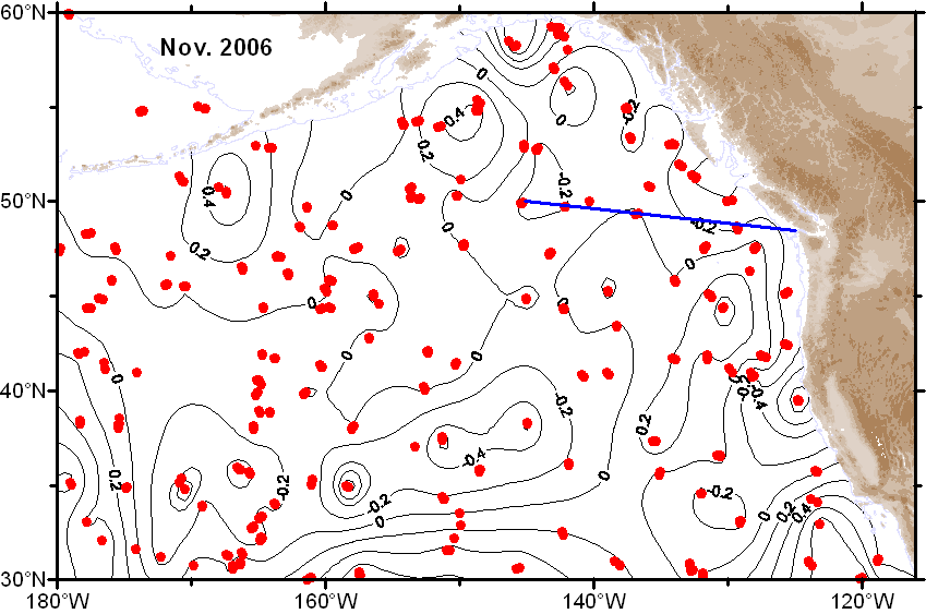
| November |
 Ψ-Map Ψ-Map
|
 ε-Map ε-Map
|
 V-Map V-Map
|
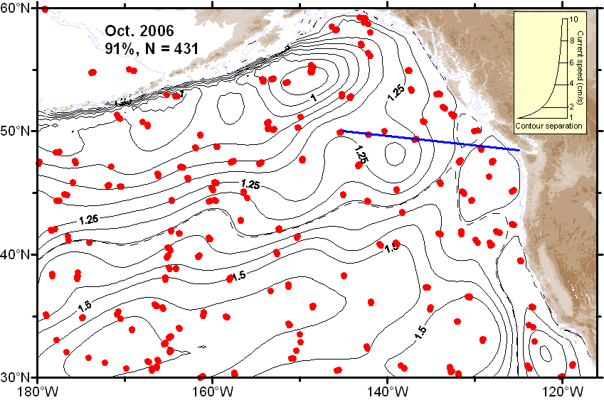
| October |
 Ψ-Map Ψ-Map
|
 ε-Map ε-Map
|
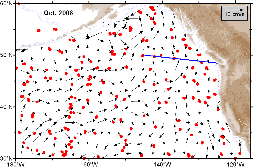 V-Map V-Map
|
| September |
 Ψ-Map Ψ-Map
|
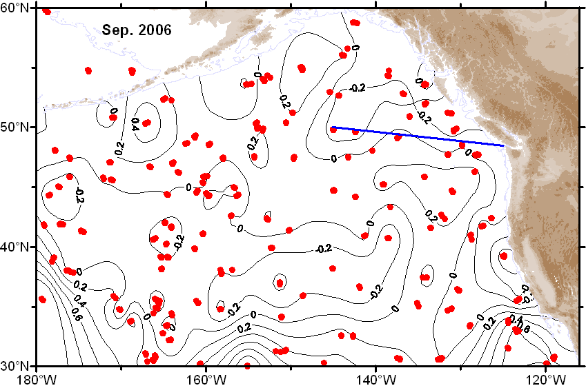 ε-Map ε-Map
|
 V-Map V-Map
|
| August |
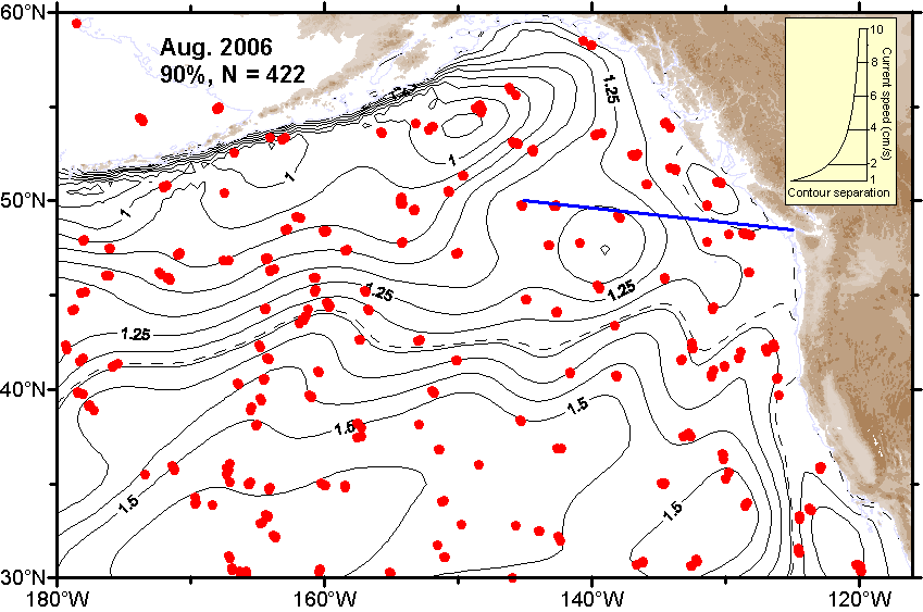 Ψ-Map Ψ-Map
|
 ε-Map ε-Map
|
 V-Map V-Map
|
| July |
 Ψ-Map Ψ-Map
|
 ε-Map ε-Map
|
 V-Map V-Map
|
| June |
 Ψ-Map Ψ-Map
|
 ε-Map ε-Map
|
 V-Map V-Map
|
| May |
 Ψ-Map Ψ-Map
|
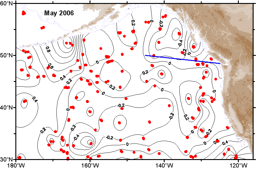 ε-Map ε-Map
|
 V-Map V-Map
|
| April |
 Ψ-Map Ψ-Map
|
 ε-Map ε-Map
|
 V-Map V-Map
|
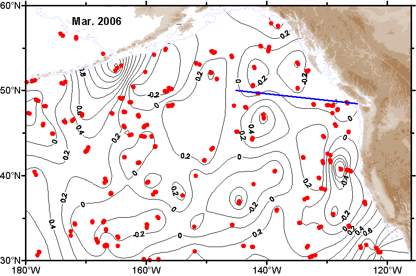
| March |
 Ψ-Map Ψ-Map
|
 ε-Map ε-Map
|
 V-Map V-Map
|
| February |
 Ψ-Map Ψ-Map
|
 ε-Map ε-Map
|
 V-Map V-Map
|
| January |
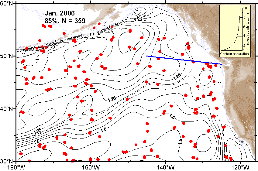 Ψ-Map Ψ-Map
|
 ε-Map ε-Map
|
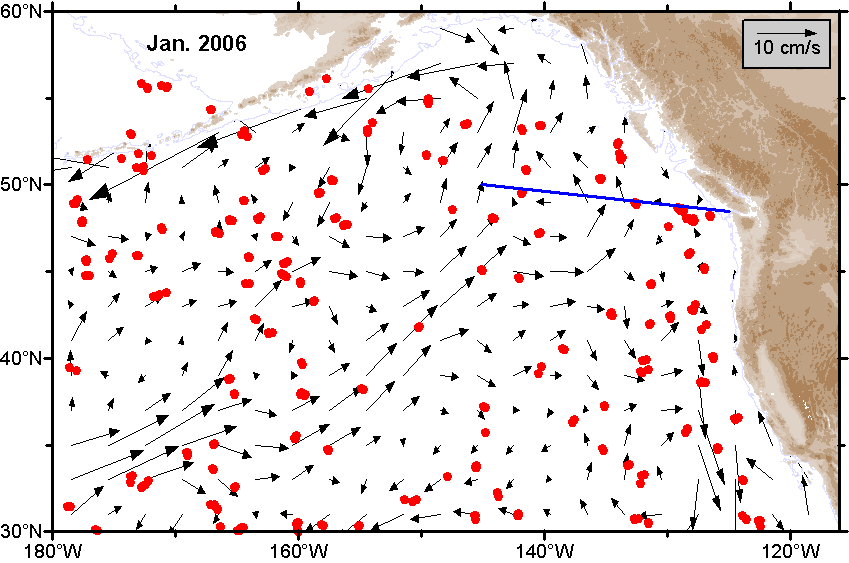 V-Map V-Map
|
2005 |
|||
| Month | Circulation maps | Error maps | Velocity maps |
|---|---|---|---|
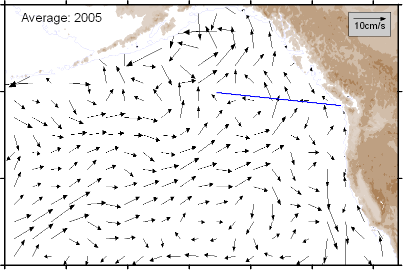
| Average |
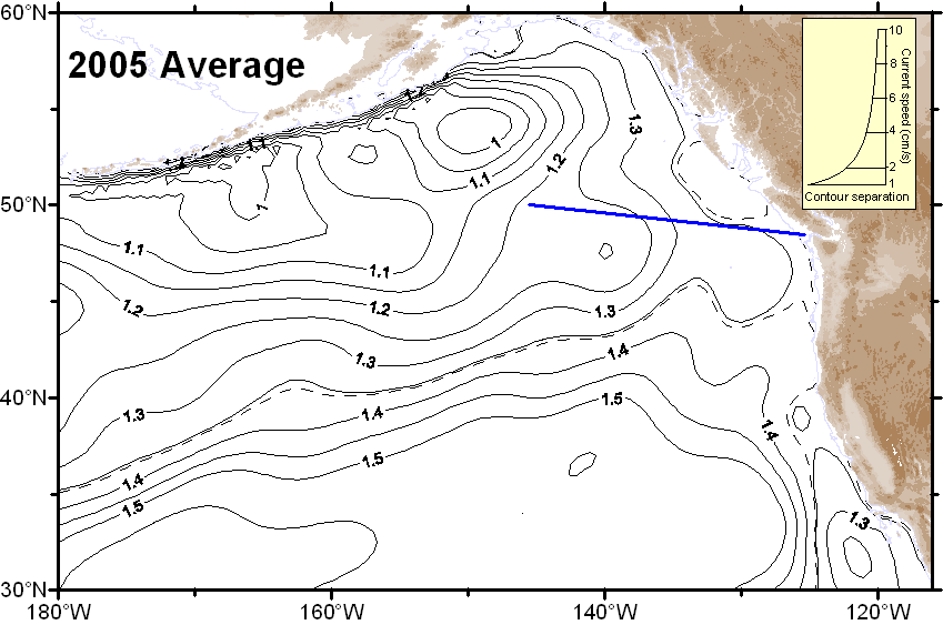 Ψ-Map Ψ-Map
|
ε-Map |
 V-Map V-Map
|
| December |
 Ψ-Map Ψ-Map
|
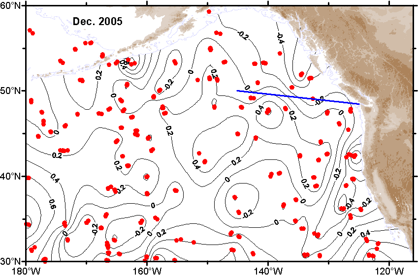 ε-Map ε-Map
|
 V-Map V-Map
|
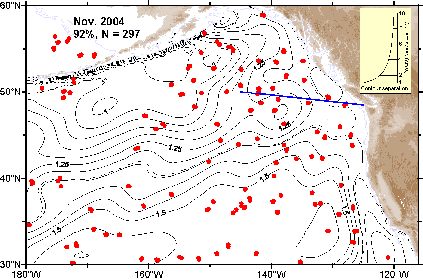
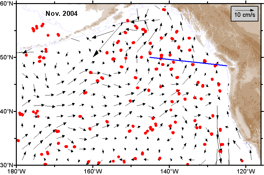
| November |
 Ψ-Map Ψ-Map
|
 ε-Map ε-Map
|
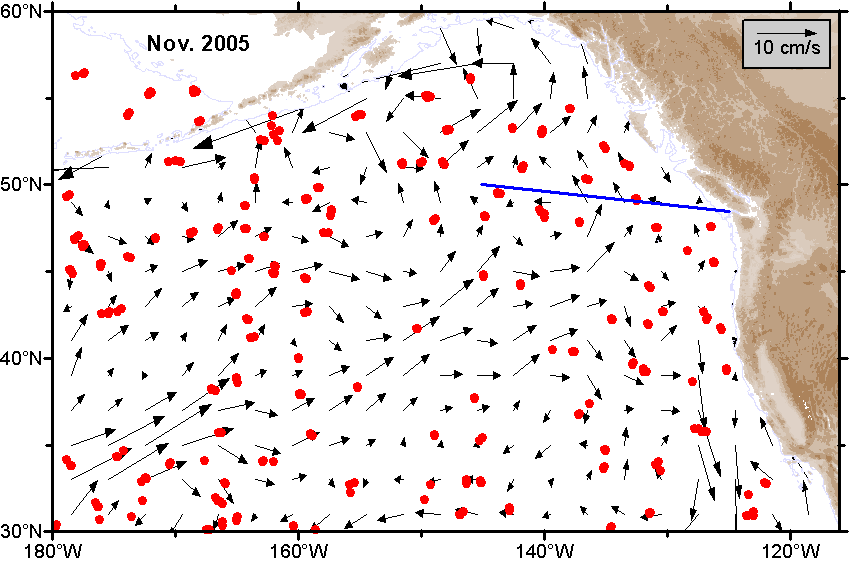 V-Map V-Map
|
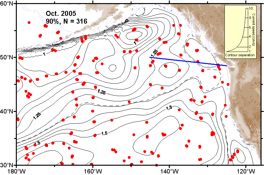
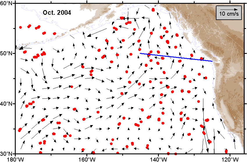
| October |
 Ψ-Map Ψ-Map
|
 ε-Map ε-Map
|
 V-Map V-Map
|
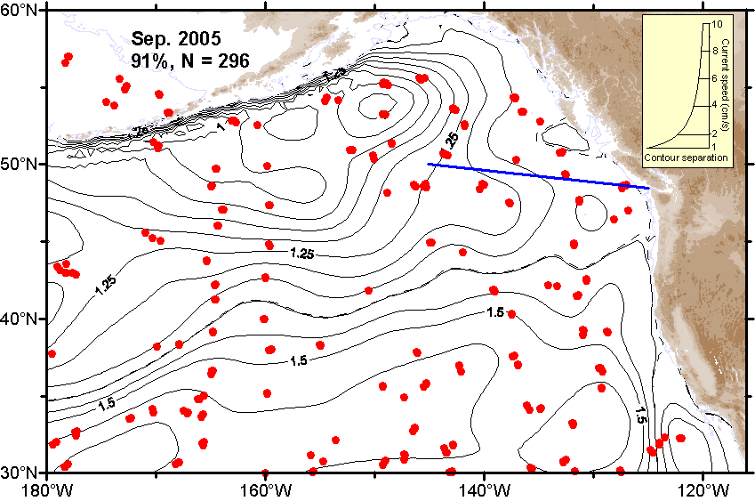
| September |
 Ψ-Map Ψ-Map
|
 ε-Map ε-Map
|
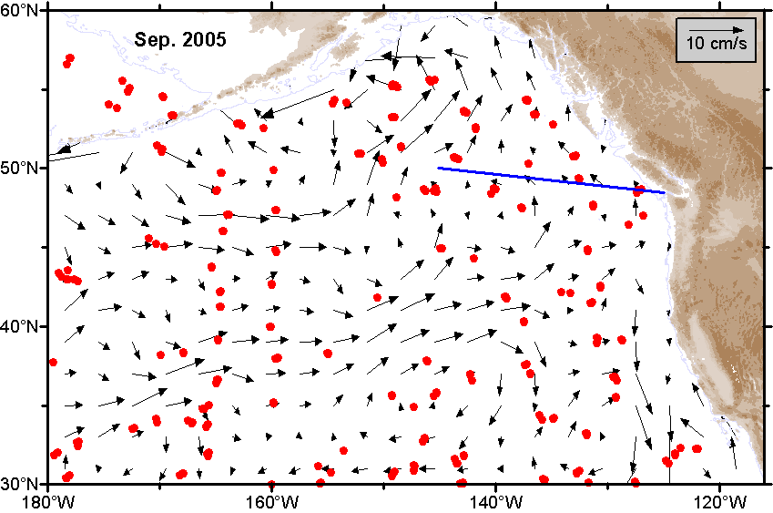 V-Map V-Map
|
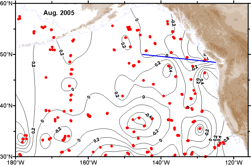
| August |
 Ψ-Map Ψ-Map
|
 ε-Map ε-Map
|
 V-Map V-Map
|
| July |
 Ψ-Map Ψ-Map
|
 ε-Map ε-Map
|
 V-Map V-Map
|
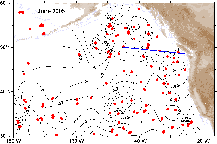
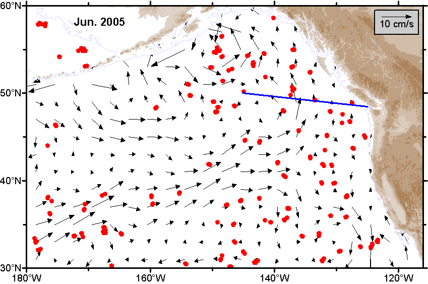
| June |
 Ψ-Map Ψ-Map
|
 ε-Map ε-Map
|
 V-Map V-Map
|
| May |
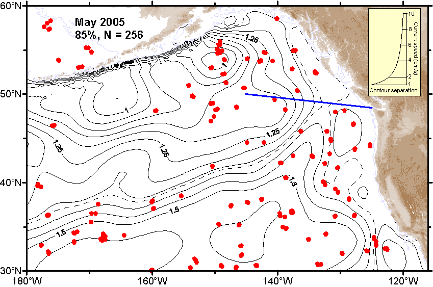 Ψ-Map Ψ-Map
|
 ε-Map ε-Map
|
 V-Map V-Map
|
| April |
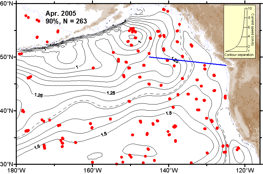 Ψ-Map Ψ-Map
|
 ε-Map ε-Map
|
 V-Map V-Map
|
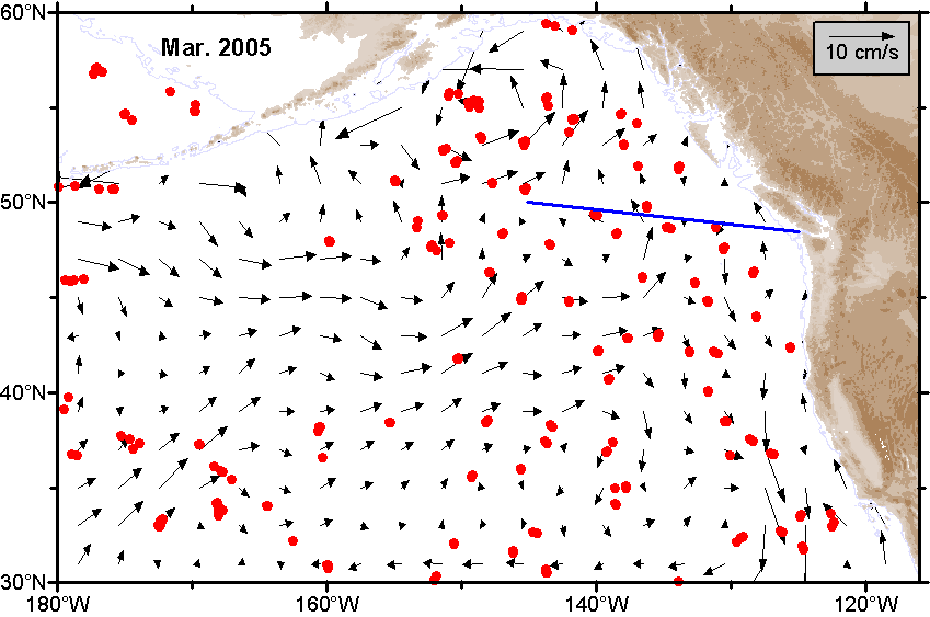
| March |
 Ψ-Map Ψ-Map
|
 ε-Map ε-Map
|
 V-Map V-Map
|
| February |
 Ψ-Map Ψ-Map
|
 ε-Map ε-Map
|
 V-Map V-Map
|
| January |
 Ψ-Map Ψ-Map
|
 ε-Map ε-Map
|
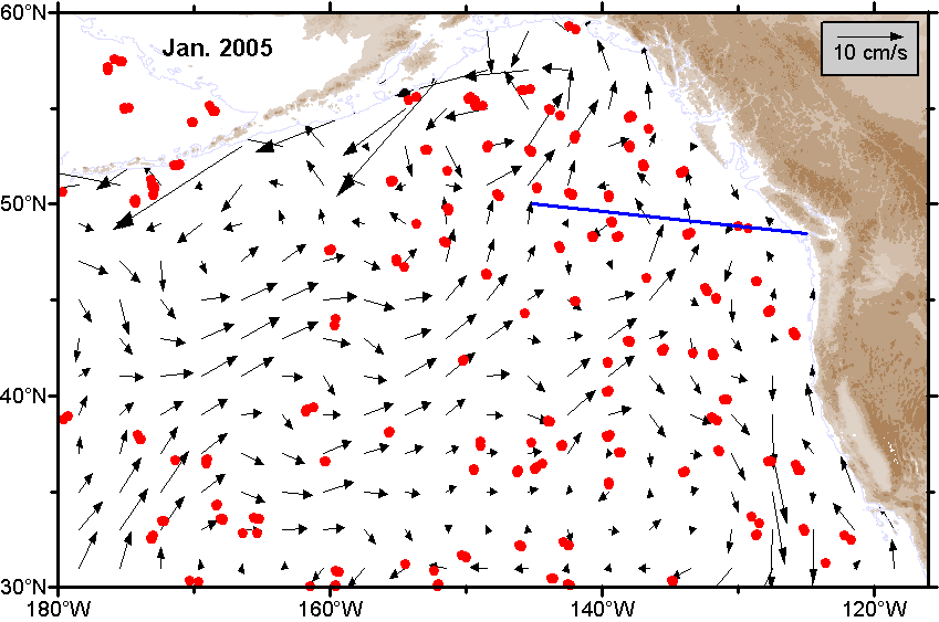 V-Map V-Map
|
2004 |
|||
| Month | Circulation maps | Error maps | Velocity maps |
|---|---|---|---|
| Average |
 Ψ-Map Ψ-Map
|
ε-Map |
 V-Map V-Map
|
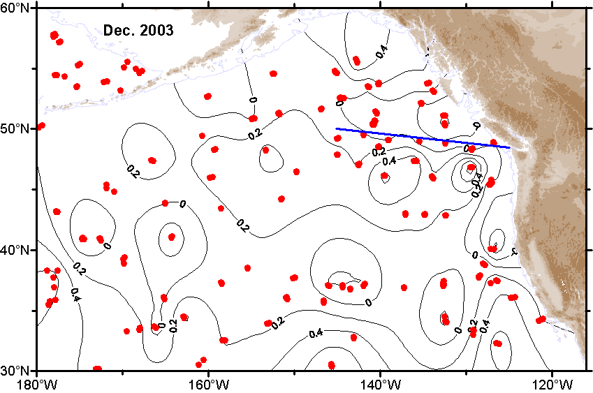
| December |
 Ψ-Map Ψ-Map
|
 ε-Map ε-Map
|
 V-Map V-Map
|
| November |
 Ψ-Map Ψ-Map
|
 ε-Map ε-Map
|
 V-Map V-Map
|
| October |
 Ψ-Map Ψ-Map
|
 ε-Map ε-Map
|
 V-Map V-Map
|
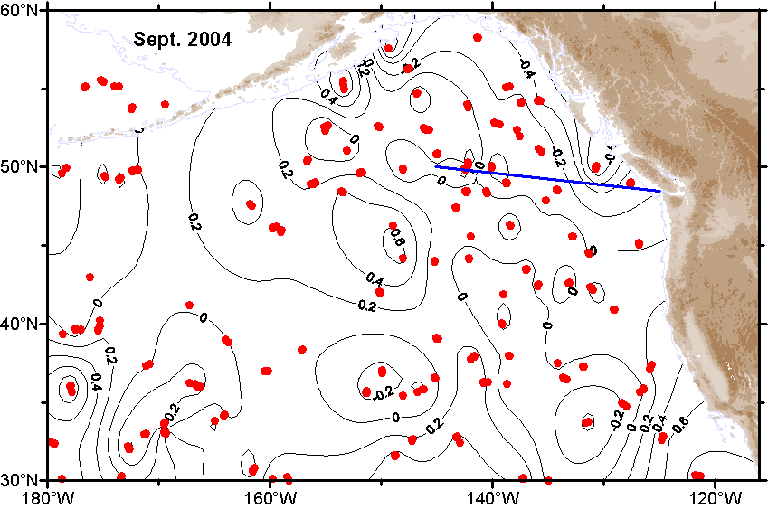
| September |
 Ψ-Map Ψ-Map
|
 ε-Map ε-Map
|
 V-Map V-Map
|
| August |
 Ψ-Map Ψ-Map
|
 ε-Map ε-Map
|
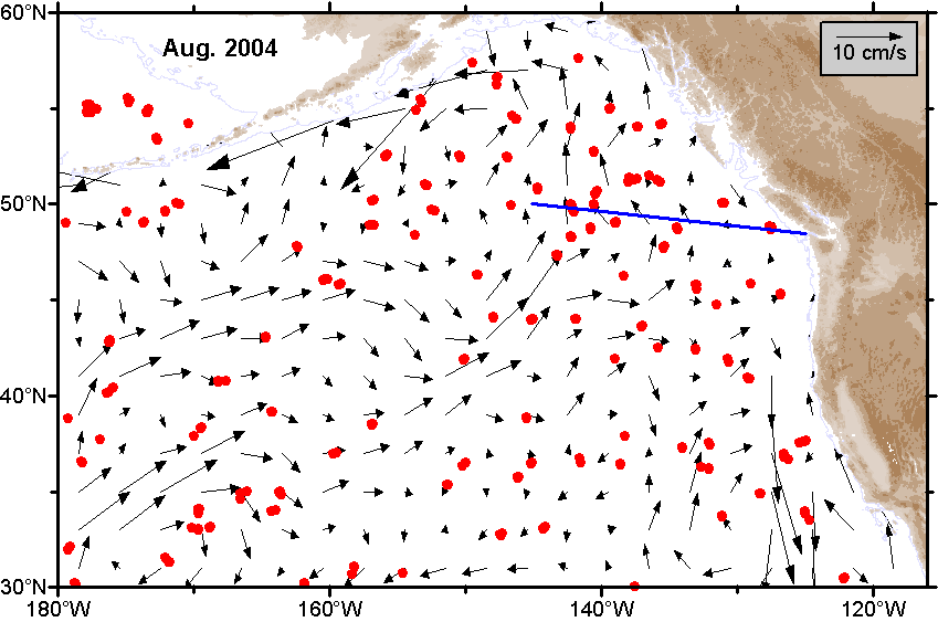 V-Map V-Map
|
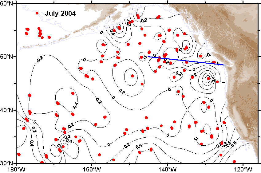
| July |
 Ψ-Map Ψ-Map
|
 ε-Map ε-Map
|
 V-Map V-Map
|
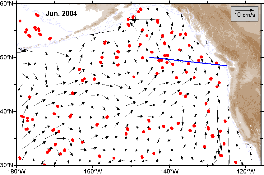
| June |
 Ψ-Map Ψ-Map
|
 ε-Map ε-Map
|
 V-Map V-Map
|
| May |
 Ψ-Map Ψ-Map
|
 ε-Map ε-Map
|
 V-Map V-Map
|
| April |
 Ψ-Map Ψ-Map
|
 ε-Map ε-Map
|
 V-Map V-Map
|
| March |
 Ψ-Map Ψ-Map
|
 ε-Map ε-Map
|
 V-Map V-Map
|
| February |
 Ψ-Map Ψ-Map
|
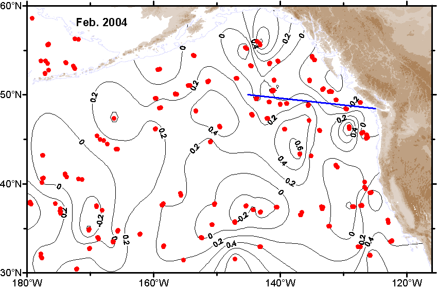 ε-Map ε-Map
|
 V-Map V-Map
|
| January |
 Ψ-Map Ψ-Map
|
 ε-Map ε-Map
|
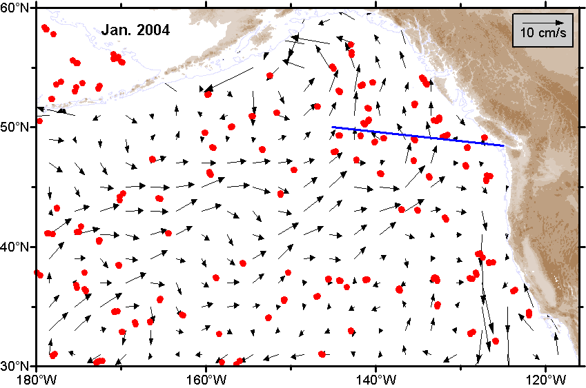 V-Map V-Map
|
2003 |
|||
| Month | Circulation maps | Error maps | Velocity maps |
|---|---|---|---|
| Average |
 Ψ-Map Ψ-Map
|
ε-Map |
 V-Map V-Map
|
| December |
 Ψ-Map Ψ-Map
|
 ε-Map ε-Map
|
 V-Map V-Map
|
| November |
 Ψ-Map Ψ-Map
|
 ε-Map ε-Map
|
 V-Map V-Map
|
| October |
 Ψ-Map Ψ-Map
|
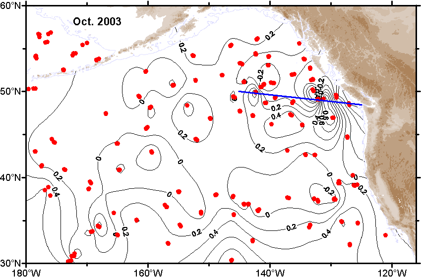 ε-Map ε-Map
|
 V-Map V-Map
|
| September |
 Ψ-Map Ψ-Map
|
 ε-Map ε-Map
|
 V-Map V-Map
|
| August |
 Ψ-Map Ψ-Map
|
 ε-Map ε-Map
|
 V-Map V-Map
|
| July |
 Ψ-Map Ψ-Map
|
 ε-Map ε-Map
|
 V-Map V-Map
|
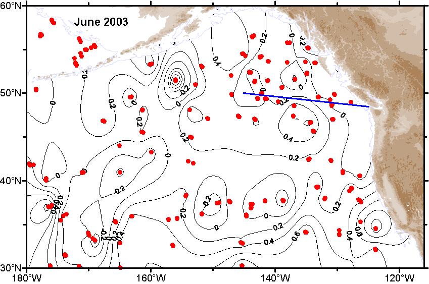
| June |
 Ψ-Map Ψ-Map
|
 ε-Map ε-Map
|
 V-Map V-Map
|
| May |
 Ψ-Map Ψ-Map
|
 ε-Map ε-Map
|
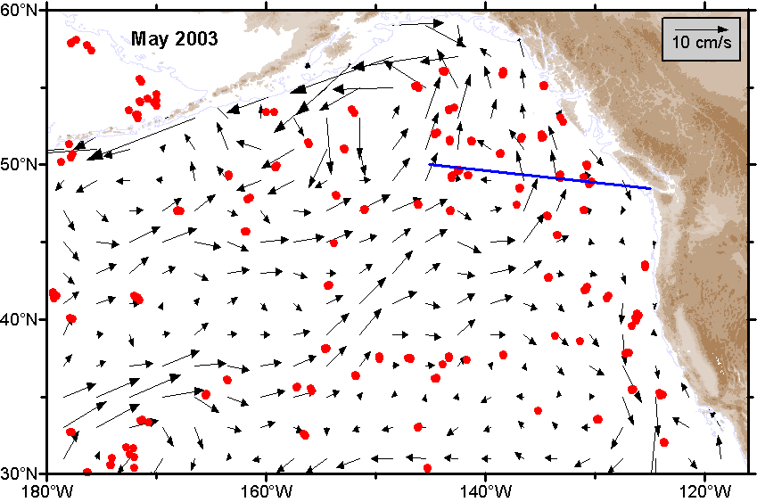 V-Map V-Map
|
| April |
 Ψ-Map Ψ-Map
|
 ε-Map ε-Map
|
 V-Map V-Map
|
| March |
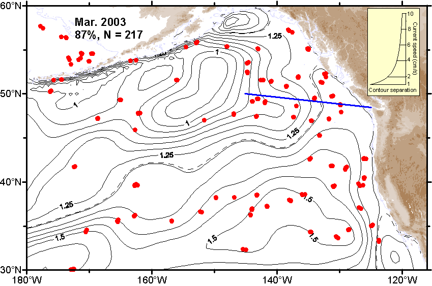 Ψ-Map Ψ-Map
|
 ε-Map ε-Map
|
 V-Map V-Map
|
| February |
 Ψ-Map Ψ-Map
|
 ε-Map ε-Map
|
 V-Map V-Map
|
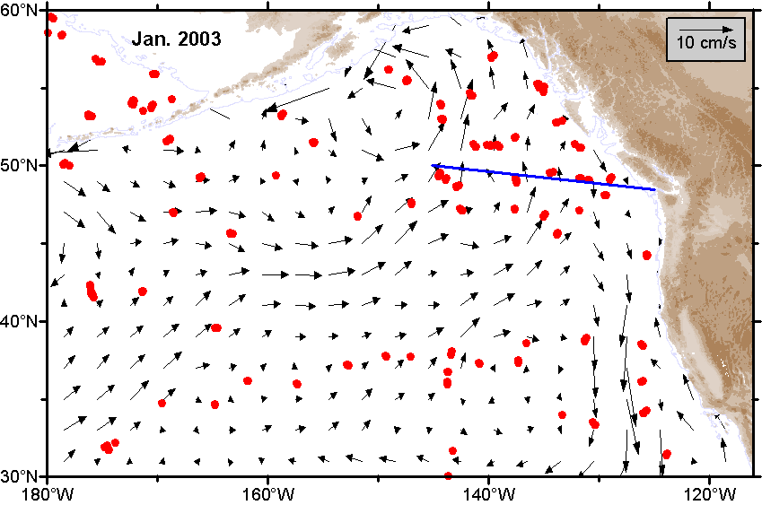
| January |
 Ψ-Map Ψ-Map
|
 ε-Map ε-Map
|
 V-Map V-Map
|
2002 |
|||
| Month | Circulation maps | Error maps | Velocity maps |
|---|---|---|---|
| Average |
 Ψ-Map Ψ-Map
|
ε-Map |
 V-Map V-Map
|
| December |
 Ψ-Map Ψ-Map
|
 ε-Map ε-Map
|
 V-Map V-Map
|
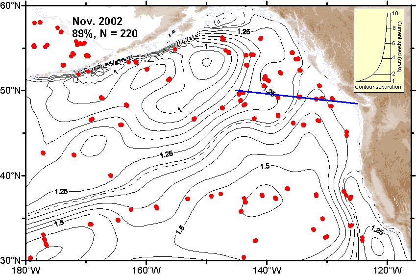
| November |
 Ψ-Map Ψ-Map
|
 ε-Map ε-Map
|
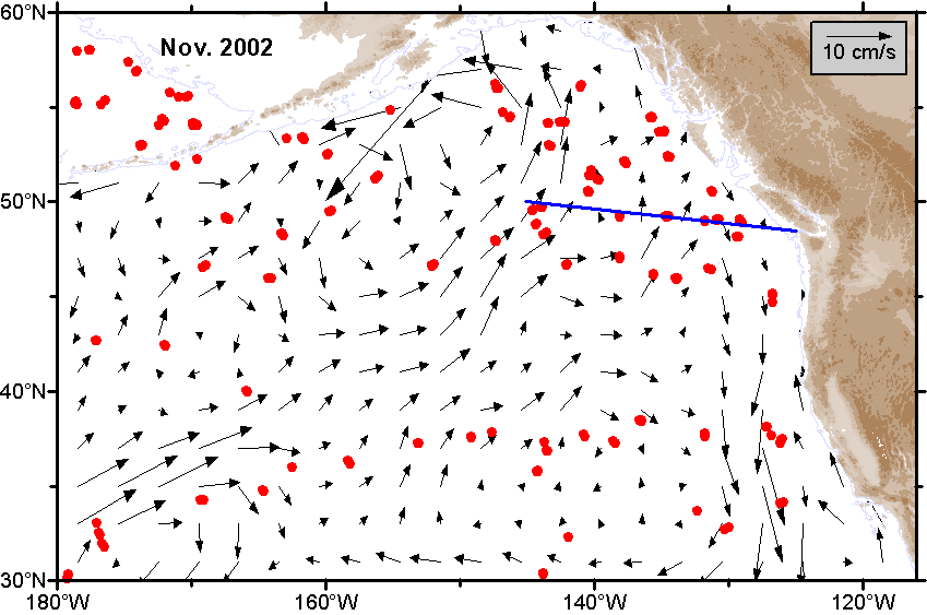 V-Map V-Map
|
| October |
 Ψ-Map Ψ-Map
|
 ε-Map ε-Map
|
 V-Map V-Map
|
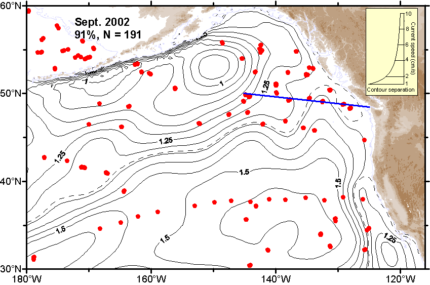
| September |
 Ψ-Map Ψ-Map
|
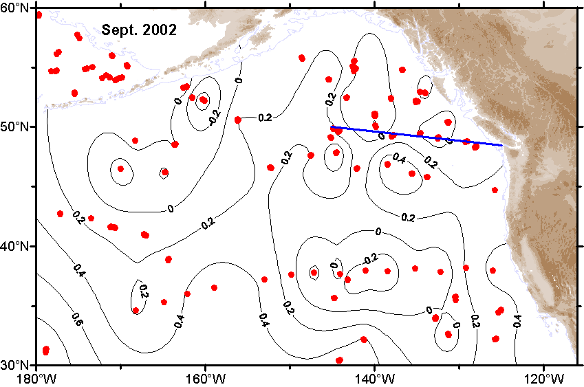 ε-Map ε-Map
|
 V-Map V-Map
|
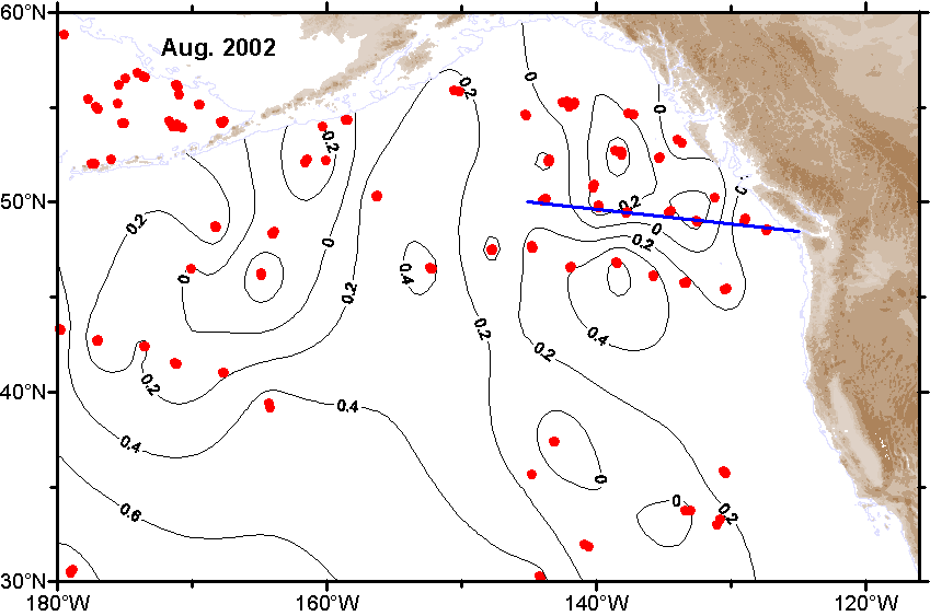
| August |
 Ψ-Map Ψ-Map
|
 ε-Map ε-Map
|
 V-Map V-Map
|
| July |
 Ψ-Map Ψ-Map
|
 ε-Map ε-Map
|
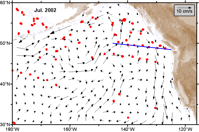 V-Map V-Map
|
| June |
 Ψ-Map Ψ-Map
|
 ε-Map ε-Map
|
 V-Map V-Map
|
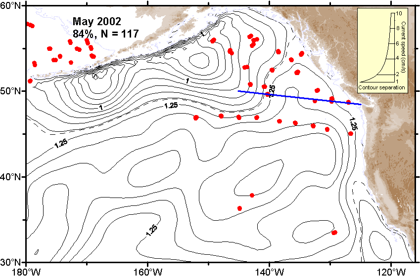
| May |
 Ψ-Map Ψ-Map
|
 ε-Map ε-Map
|
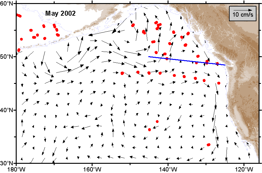 V-Map V-Map
|
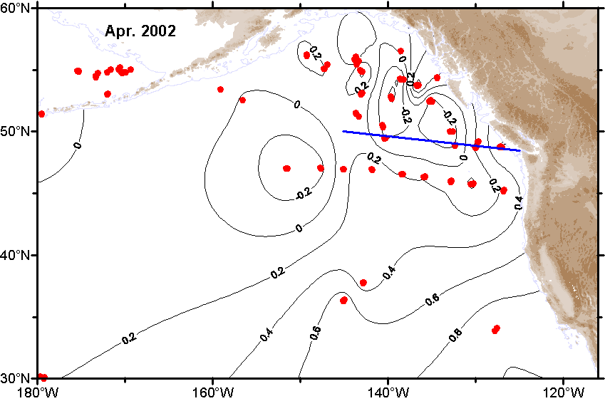
| April |
 Ψ-Map Ψ-Map
|
 ε-Map ε-Map
|
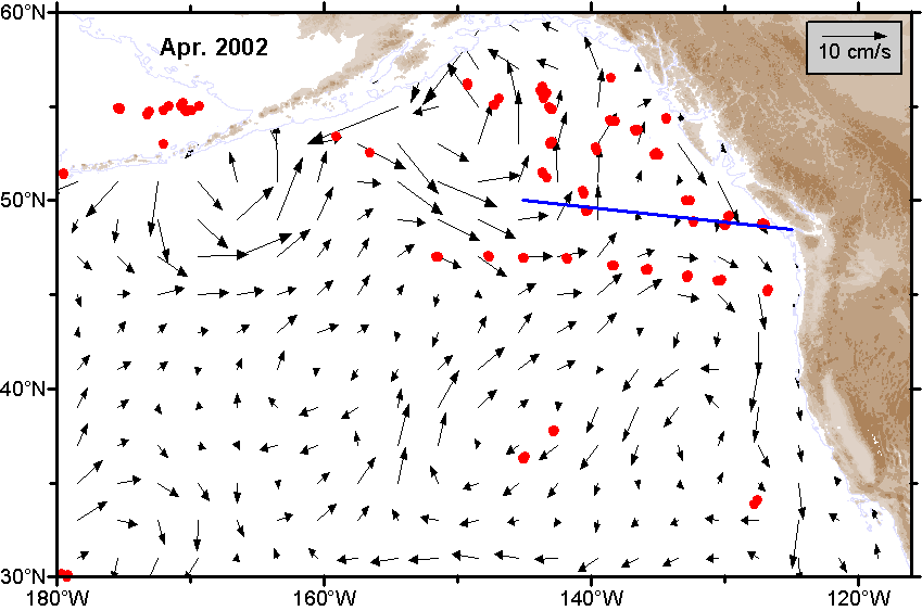 V-Map V-Map
|
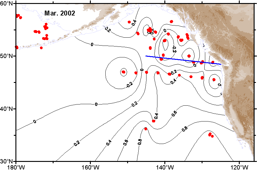
| March |
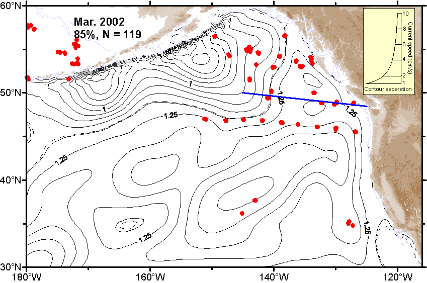 Ψ-Map Ψ-Map
|
 ε-Map ε-Map
|
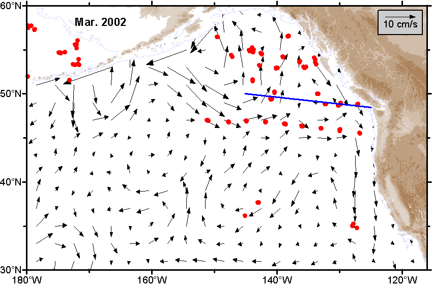 V-Map V-Map
|
| February |
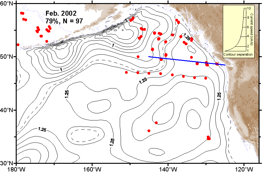 Ψ-Map Ψ-Map
|
 ε-Map ε-Map
|
 V-Map V-Map
|
| January |
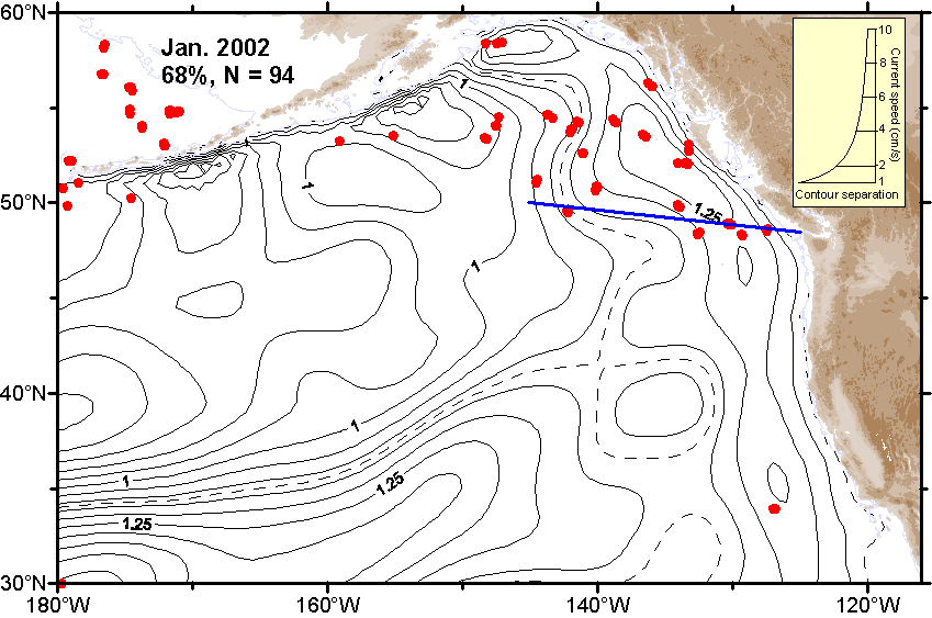 Ψ-Map Ψ-Map
|
 ε-Map ε-Map
|
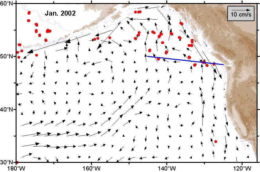 V-Map V-Map
|
NB: Very recent maps of properties of the Gulf of Alaska
For the "current month" and the current year "so far" the maps have been computed using whatever data are available to the present time. These maps are subject to change. Typically a final map for a given month will be posted about the 4th day of the following month. The final version for the annual average will be posted when all data are available.
- Date modified: